Today marks the official start of the 2022 Hurricane Season. For the first time since 2014, we actually have not seen any preseason tropical development, which became quite a common occurrence over the last seven years! However, we are on the cusp of having our first tropical system.
The last time we spoke, Hurricane Agatha was nearing landfall along Mexico’s southwestern Pacific coastline, and the National Hurricane Center was giving 40% odds that the storm’s remnants would emerge over the Gulf or Caribbean and develop into a new tropical system.
Since then, we have seen the remnants of Agatha work across southern Mexico. We are now seeing those remnants emerge off of the Yucatan Peninsula this morning. The satellite loop above shows that we are seeing increased storminess and a general swirl in the atmosphere with this convection. This suggests that the system is getting better organized, and may begin to acquire tropical characteristics soon.

As of the 8AM EDT update Wednesday morning, the National Hurricane Center has significantly increased development odds for this to happen. The NHC now pegs development chances at nearly 80% over the next 5 days, and 70% over the next 2 days. This means that development is highly likely to occur with this developing system. If it becomes a named storm, it would earn the name “Alex.”
The red shaded zone would be approximately where we would expect the development to occur. This does not necessarily mean that this is the storm’s projected path. There are still questions about where development will exactly occur, which would lead to changes in its future path.
If development were to occur south of the Yucatan, where the convection is now, then it would pose a greater risk to southern Florida and Cuba as it tracks northeastward. Conversely, if we see the convection start to shift northward, and development happens north of the Yucatan, then central Florida may have the greatest risk as it tracks northeastward. The exact point of development is key here.
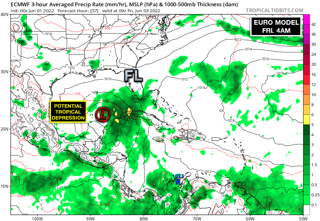
The latest run of the European model suggests that we see the convection slowly shift northward, towards the tip of the Yucatan, which is entirely plausible. This model shows a potential Tropical Depression or low-end Tropical Storm developing as soon as Thursday night/Friday morning. With high pressure to the south and north, they will act to funnel the storm northeastward.
The European model then develops this system into a mid-range Tropical Storm, making a weekend landfall along Florida’s western coastline. At this point, this system would not be overly strong and would pose a greater heavy rain risk than anything else.
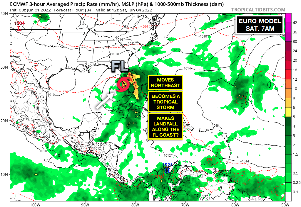
Again, the exact point of development will greatly affect where exactly this storm goes. If development occurs 50-100 miles further south, then you would take this potential track 50-100 further south as well. Regardless, it is likely to interact with land in some form, whether it’s Florida, or Cuba and the Bahamas, early this weekend.
The European model then depicts the storm continuing northeastward into the open Atlantic. On this track, it would cross over the Gulf Stream, home to warmer waters. This could allow this potential storm to strengthen, potentially becoming a hurricane.
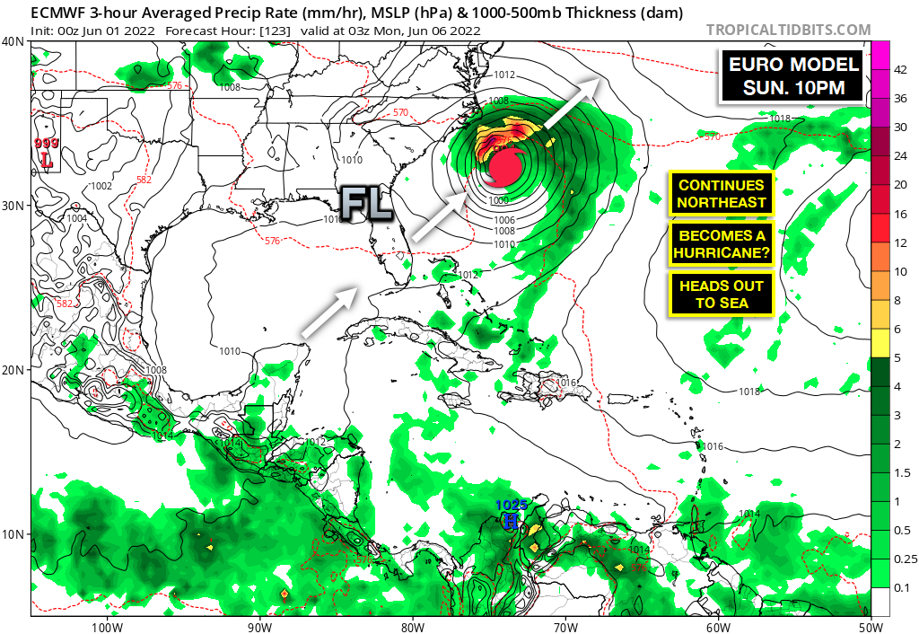
Its position off of the Southeast coastline may appear concerning at first glance. However, this storm is likely to be racing northeast, away from landfall after crossing Florida. It does not appear that there would be sufficient atmospheric steering currents to curve the storm towards the East Coast, which is great news.
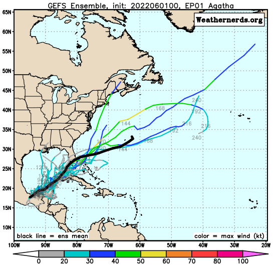
At this point, direct impacts do not appear likely outside of Florida. However, increased rip currents would be likely for shorelines this weekend and early next week. Our “spaghetti models” at this point all seem to agree that this system should be moving out to sea as we head towards next week. But again, we will wait and see if any new developments lead to a change with this.
Welcome to hurricane season, folks!
Stay with JB Weather for the latest information on Southern Maryland weather. You can always access my forecasts and updates here on the website, on Facebook, on Twitter, on Instagram, and on YouTube.
-JB
John Bordash
View More PostsJB Weather forecaster John Bordash is working around the clock to provide Southern Maryland, and neighboring communities, with accurate and reliable weather information.