Brought to you by OakPoint Insurance
This afternoon, I continue to monitor the storm threat the region has late this weekend. Since we last spoke about this, the picture is coming into focus on the setup and potential scenarios that could be in play. The one thing that we have felt sure about from the beginning is that we will see a fresh injection of cold air settle into the region on Saturday. A substantial area of high pressure will develop across southern Canada, which will help send frigid air southward. On Saturday, we may struggle to get into the 30s, with areas north of DC likely staying locked into the lower to middle 20s. This bout of cold air will set the stage for our storm system late Sunday.
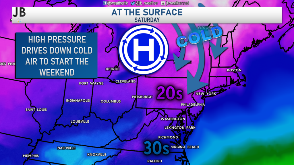
The Setup
Atmospheric energy will move onshore of the Pacific northwest late Thursday. It will develop into a storm system across southwestern Canada by Friday. This developing system will dive southward through the Plains, delivering a stripe of snow through the country’s mid-section. By Saturday, this area of low pressure will eventually make its way down towards the Gulf Coast as our arctic high gets established in southern Canada. All of this looks pretty certain to happen. Granted, some variables are still unknown and in play with parts of this forecast, such as how strong the storm is and how well organized the associated atmospheric energy becomes.
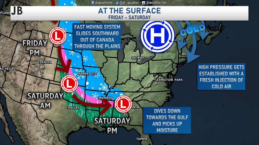
Once the storm system reaches the Gulf Coast, it will have a few options in its forward track. An ocean storm will develop on Thursday & Friday out in the Atlantic and will move northward into the Canadian Maritimes. The ocean storm will not likely bring any direct impacts to Southern Maryland. However, it will dictate the storm track of the developing system in the southern US on Saturday.
Once in the southern US, our system will likely die off as it reaches the southern Appalachians, and redevelop a new area of low pressure to the east, near the Carolina coast. The slower and stronger the ocean storm is late this week, the further east this new southern storm will be allowed to come.
Scenarios
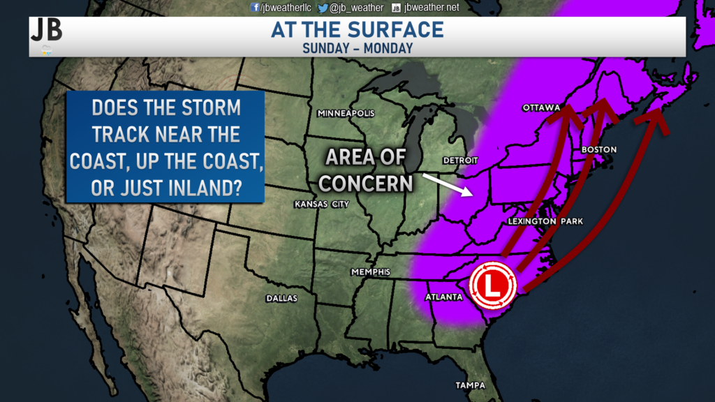
Since yesterday, the potential for this storm to harmlessly slide out to sea has become very unlikely. It appears likely, if not close to certain, that this system will be coming northward in some fashion. Just how close to the coast remains unknown. Let’s dive into my updated probabilities!
Near the Coast
Overview: This would be the best-case scenario for Mid-Atlantic snow lovers. The ocean storm would move into the Canadian Maritimes at a slower clip, allowing the storm track to remain flatter a tad longer, leading to a track further offshore. The storm would also be moderately strong. This would favor areas along and east of I-95 to see the heaviest snow.
Locally: This would lead to an accumulating snowfall for much of the Mid-Atlantic with enough cold air present. It would be too early to predict totals, but accumulation would be likely in our area.
Probability: 25% Chance. The probabilities for this scenario are decreasing a tad, but are not zero. Much of our guidance has shifted away from this option, but further southeast trends towards this potential are still very much possible.
Up the Coast
Overview: This solution would offer mixed results for our region. The ocean storm would move out of the picture quicker, allowing the storm track to turn northward sooner, leading to this storm tracking further west, right along the Atlantic coastline as the high to the north gradually weakens and moves east. This would favor areas west of I-95 to see the heaviest snow.
Locally: This would likely lead to a snow to mix to rain solution locally. The high pressure from Saturday would ensure that we would start with wintry weather. However, that would switch to rain as the system tracks further north.
Probability: 35% Chance. This solution has a decent chance of happening. Today’s run of the European model shows a solution that is close to this potential. This is one of our leading contenders for the future of this system.
Inland Track
Overview: This would be the worst-case for Mid-Atlantic snow lovers. In this scenario, the ocean storm would move out in plenty of time and our storm system would be plenty strong. The resulting storm track would be allowed to buckle northward much sooner, allowing a track near I-95. This would favor areas west of I-81 to see the heaviest snow.
Locally: This would likely lead to quick burst of snow Sunday afternoon before a quick switch to rain. The rain could be heavy at times with gusty winds. There would be some concern for coastal flooding as well.
Probability: 40% Chance. This solution is what much of our guidance has been trending towards. There will likely be a limit to how far west this storm can track. However, anything west of the Bay would lead to more wet than white solution.
Shown above is how our Futurecast model handles this system. Our model here is much quicker with the system, moving potential precip into the region as early as midday Sunday. This model seems to be somewhere in between the “Up the Coast” solution and the “Inland Track” solution that I outlined. Much of the Mid-Atlantic starts with snow, but as warmer air works in aloft, many spots switch over to rain. This model has the precip getting out of our region Sunday night/early Monday morning. I would be very hesitant to latch on to this exact model output, as this is likely to change as we learn more information. This is just to serve as a frame of reference for you.
Summary
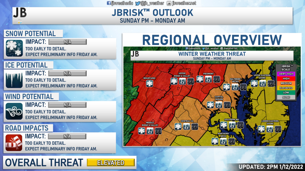
There is a lot of uncertainty with this forecast– which makes sense. We’re still around 4 days out from this system potentially affecting us. It will be hard to say what will happen until we get more answers on this system and its atmospheric drivers. Right now, I think much of the Mid-Atlantic should be on alert for the winter weather potential, even if that means that rain may mix in at some point. With that in mind, I have highlighted much of the region as having varying threats from this potential system. We will get into more details tomorrow and issue a first call forecast on Friday. It will be essential to stay away from hype and any snow maps you may see floating around the internet. It is far too early to say for sure what anyone will see from this system.
Stay with JB Weather for the latest information on impacts here in Southern Maryland. You can always access my forecasts and updates here on the website, on Facebook, on Twitter, and on YouTube. JB Weather is Southern Maryland’s Weather Leader, and I am working around the clock to keep you ahead of any storm!
-JB

The premier insurance agency in Southern Maryland with three locations. We provide insurance for Home, Auto, Business, Farm, and Life. In partnership with many top insurers, we provide solutions to fit our client’s needs. Get in touch with us at 301-863-8100 to experience the difference, mention JB Weather to claim your free gift!
1 thought on “Update: Picture Beginning to Emerge on the Weekend Threat”
Comments are closed.
[…] [ January 12, 2022 ] Update: Picture Beginning to Emerge on the Weekend Threat Top Stories […]