Brought to you by Dugan, McKissick, Longmore LLC
As we approach the heart of hurricane season, we are beginning to see the tropical Atlantic wake back up. More importantly, we are seeing the heart of the Atlantic Basin, known as the Main Development Region (MDR for short) begin to get more active. The MDR is the region between the coast of Africa and the Lesser Antilles where the majority of our storms form in any given season.
A system moving across the MDR has been gradually organizing over the last few days. While this system is not an official tropical cyclone as of when this article was published, the system has been dubbed Invest 95-L. The National Hurricane Center does now give Invest 95-L high odds, around 70%, of developing into a tropical cyclone over the next 5 days. If this system does indeed develop, it would earn the name Grace.
Invest 95-L has been gradually organizing and is likely to become a tropical cyclone over the next few days. While this system is not a threat to land at the moment, there are many questions about where it may eventually end up tracking. Current computer guidance shows Invest 95-L continuing to track westward, and potentially impacting the Lesser Antilles, and potentially Puerto Rico, in about three days. From that point, its future will be heavily dictated by any interaction it has with land, the amount of wind shear it faces, and the exact positioning of a Bermuda high to the north.
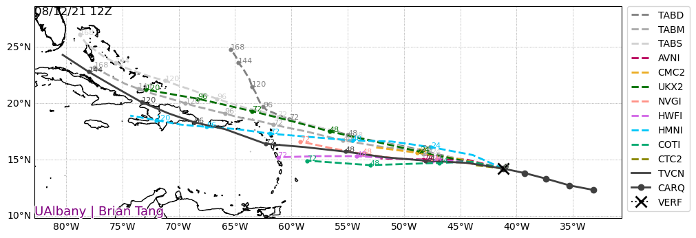
Shown below are the infamous Spaghetti model plots for this system over the next five days. Most models are in agreement with the westward track over the next three days. From there, the models begin to vary on their eventual tracks of the system.
Invest 95-L is setting in a decent environment for intensification. The model guidance is generally in agreement with the continued gradual strengthening of this system for the next few days. Shown below is the model guidance intensity forecast. Each line represents a different model, and they all plot out intensity over time. Right now, Invest 95-L is not favored to undergo any rapid intensification but could eventually become a strong tropical storm before its approach to the Lesser Antilles. In the long-term, wind shear and land interaction may look to weaken the storm depending on how each impacts the system. A key example of this would be Tropical Depression Fred. The system has significantly weakened since moving over the mountainous island of Hispaniola last night.

Only time will tell how Invest 95-L will play out. What seems likely right now is for this system to continue strengthening, and to become a tropical cyclone over the next few days. What Invest 95-L becomes will track towards the Lesser Antilles by Sunday. From there the forecast track and intensity of the storm will become highly uncertain. This will be something to watch over the next week or so.
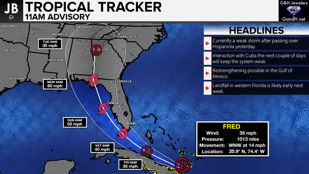
Elsewhere– Tropical Depression Fred has survived his trip across Hispaniola but is a rather weak system today. Fred will look to restrengthen in a couple of days once it gets to the Gulf. However, the more interaction with Cuba/FL the storm has, the weaker it’ll be. A landfall in FL looks likely by Monday. Any potential impacts in the Mid-Atlantic from the storm’s remnants are uncertain right now.
As we enter the heart of hurricane season, we will have to keep an eye on the tropics. The Atlantic is slowly awakening, and we are likely in store for a busy 6-8 weeks! Stay with JB Weather for the latest information on Southern Maryland weather. You can always access my forecasts and updates here on the website, on Facebook, on Twitter, and on YouTube.
-JB

Dugan, McKissick & Longmore, LLC has served our Southern Maryland community for over 25 years. Our trusted attorneys are here to handle your unique case from beginning to end. To schedule an appointment, call us today at 301-862-3764 or visit our website at www.paxlawyers.com.
John Bordash
View More PostsJB Weather forecaster John Bordash is working around the clock to provide Southern Maryland, and neighboring communities, with accurate and reliable weather information.