Brought to you by Cedar Point Federal Credit Union
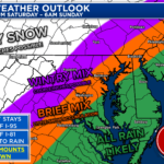
I’m continuing to track a coastal storm for this weekend. The biggest questions are:
1) How close to the coast is the track?
2) How much cold air is present
Right now, winter weather looks the most likely NW of I-95, where both are not in question. Much bigger deal SE of I-95.
It is too early to really cement down amounts. However, impactful winter weather (snow/ice) is looking likely NW of DC. Along I-95, we likely will see the dreaded rain/snow line come into play. Can our Canadian high drive down more cold air to help these areas out? We’ll see! That answer will be ironed out over the coming days.
We are still 4-5 days out, and this forecast WILL change and evolve as we learn more. We will not be able to forecast amounts, impacts, or dominant precip-type until Wednesday or Thursday. But this does give you a general idea of the probabilities we are looking at.
Right now, it appears that the timing would be Saturday evening through midday-ish on Sunday. Specifics are still in the air (along with many parts of this forecast).
Just stay weather-aware and avoid the hype out there! I will provide reliable updates throughout the week!
John Bordash
View More PostsJB Weather forecaster John Bordash is working around the clock to provide Southern Maryland, and neighboring communities, with accurate and reliable weather information.