Brought to you by Row House
After a cold start to the week, we are finally seeing warm air return to the region. Many spots got well into the 50s today, and even warmer air is on tap for tomorrow! However, that warmth will come with the price of gusty winds and the potential for overnight thunderstorms.
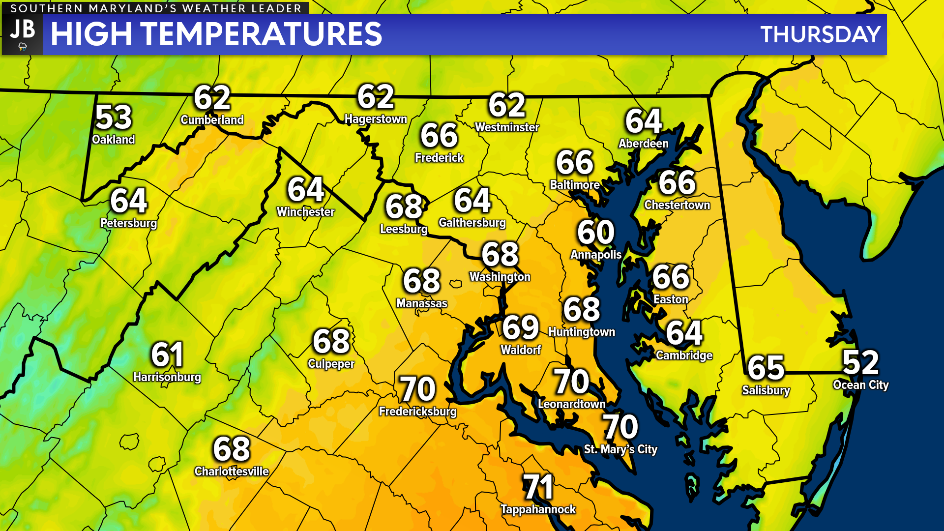
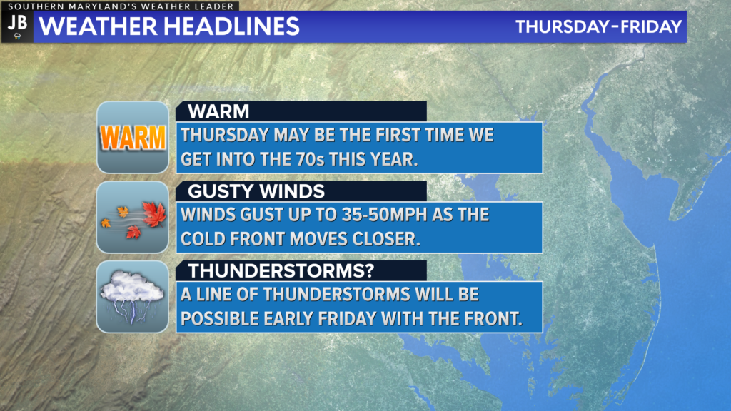
First, let’s talk about the warmth! Highs tomorrow afternoon will look to get into the upper 60s and lower 70s. Now, this will be dependent on the amount of sunshine we see. Increased cloud cover will keep temperatures down slightly.
The daylight hours on Thursday will be mostly dry, giving you plenty of opportunity to get out and enjoy the warm temps! This could be the warmest day of the year so far.
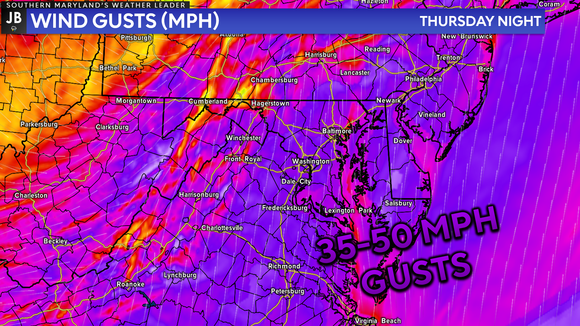
However, these warmer temperatures will come with a cost. We will see gusty southerly winds throughout the day tomorrow before the front arrives. We could see winds gust upwards of 20-35 mph during the day. As the front comes closer overnight Thursday, though, we could see winds gust as high as 50mph!
These high wind gusts would not be gusts associated with any potential thunderstorms. This means we could see a prolonged period Thursday night with wind elevated wind gusts. This could indeed lead to some spotty power outages.
Our Chesapeake’s Bounty Futurecast, which is shown above, does an excellent job of depicting the timing for potential storms. The good news is that the rain does not look as widespread as we thought earlier in the week. The soaking rain is likely to be confined to our northwest. Instead, we are likely to see a narrow band of thunderstorms work through with the cold front.
This band of thunderstorms will look to move through between 3am-8am Friday morning. This is unique timing as we don’t frequently see thunderstorms work through our region that early. Thanks to a lack of severe storm ingredients in the atmosphere, that unique timing should keep our risk of seeing severe weather down a bit.
Even with a diminished severe weather threat, this band of thunderstorms will have the potential to bring locally heavy rain and heightened wind gusts up to 60-65mph. These threats are not likely to be widespread but rather isolated within a couple of embedded thunderstorms along the line.
This potential early morning thunderstorm dynamic could certainly make for an interesting morning commute on Friday. Again, I am not expecting a severe weather outbreak with this. What I am expecting would be for the potential of embedded late-Winter thunderstorms to try and roll through. Cooler air rushes in behind this line.
In Summary… Thursday will look to offer some interesting weather! We will likely see warm temps Thursday afternoon, that may try to push 70 in spots. That warmth will come with gusty winds that will only increase after sunset. These winds could lead to some outages. Early Friday morning, we could see some low-end thunderstorms push through the region.
While the temperatures on Thursday will be warm, and you definitely enjoy them, overnight Thursday could offer some topsy-turvey weather. The wind threat could be high for some areas. The thunderstorm threat, though, does not look nearly as impactful. Do be aware of potential impacts for Friday morning though.
As always, stay with JB Weather for the latest information on Southern Maryland weather. You can always access my forecasts and updates here on the website, on Facebook, on Twitter, and on YouTube.
-JB

Row House SOMD is more than just a workout; it’s about people, connection, strength and community. Our classes offer varied programming, helping you progress your workout and avoid plateaus. In our boat there’s a seat for everyone, so contact us TODAY at 301.686.7788 and mention JB Weather to schedule a FREE introductory class. Also receive a FREE GIFT when you sign up for a membership.
John Bordash
View More PostsJB Weather forecaster John Bordash is working around the clock to provide Southern Maryland, and neighboring communities, with accurate and reliable weather information.