Brought to you by Batteries Plus
After a rather warm week, we saw a cold front move through the region on Friday and bring most of the area a decent amount of rain. Some even saw their first thunderstorms of the season before we cleared out late last night. Today has been cooler but sunny for all! However, this will all look to change overnight.
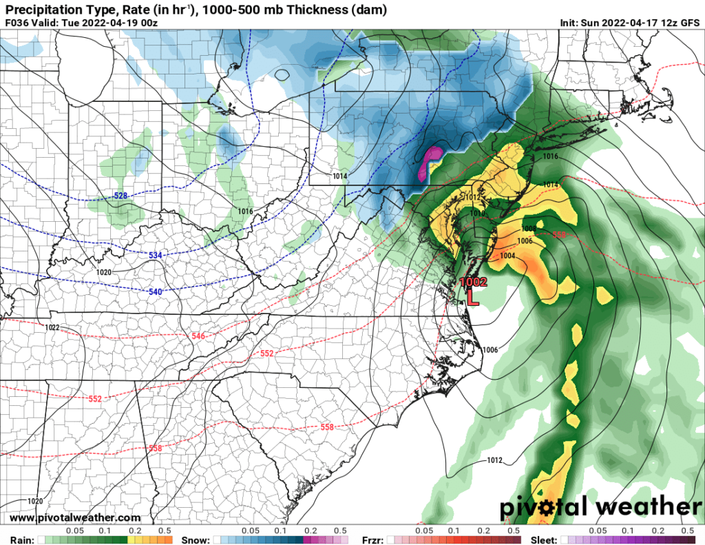
An area of low pressure will head northward overnight and move by our region throughout the day tomorrow before heading to New England. This system will be moisture-rich as it moves northward! Rain is likely for most, with some snow looking very possible for mountainous areas of the northeast.
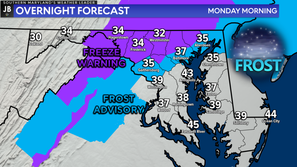
Before the rain moves in, we will see temperatures drop off quickly tonight. Many spots will look to bottom out in the 40s along the Bay and in the 30s along/NW of I-95. Frost Advisories (blue areas) and Freeze Warnings (purple areas) have been issued for tonight for the coldest zones. Aside from our most rural, inland areas most of Southern MD should be spared from a widespread frost.
Our Chesapeake’s Bounty Futurecast seems to have a good handle on how this will all unfold. We will see moisture begin to move into southwestern zones early tomorrow morning. The coldest spots in the mountains and foothills may actually see this start as a period of snow! This will be an all rain event for most of the Mid-Atlantic, though.
Rain will likely begin in Southern MD around, or just after, sunrise tomorrow morning. The rain is likely to continue throughout the day, with bands of heavy rain moving through. We are likely to see the heaviest rain fall during the afternoon and evening hours before our area of low pressure eventually pulls away late tomorrow night. We will see the rain begin to wrap up late Monday night.
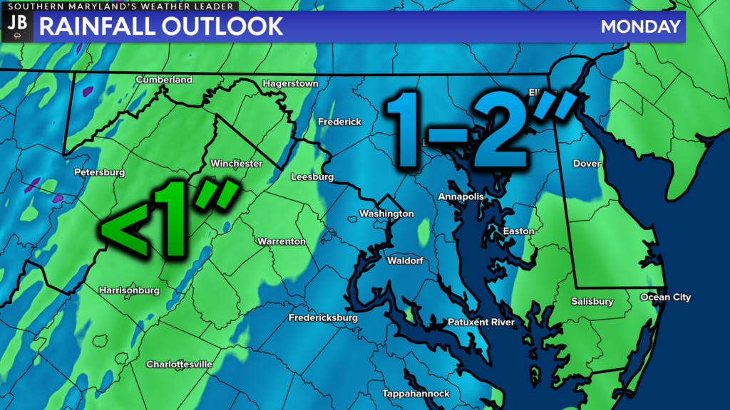
This is likely to be a widespread, moderate rainfall event for much of the region. Most of our compute guidance depicts the heaviest rainfall falling along and to the east of I-95. This would center the zone of heaviest rain right over Southern MD and the Northern Neck. 1-2″ of rain seems likely for most with some isolated pockets that could exceed 2″.
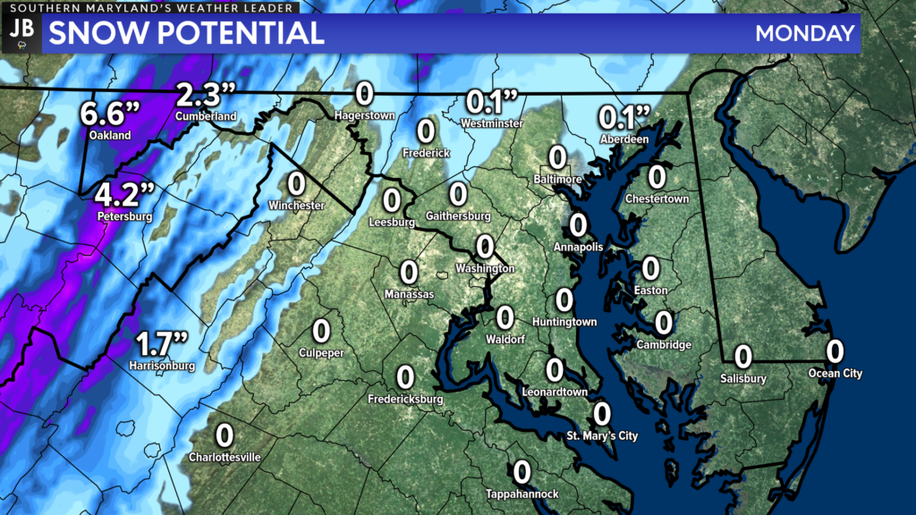
As mentioned above, snow will also be a threat for the highest elevations out west. It is crazy that we are still talking about snow in mid-April! Thankfully, this will not pose a threat to our local region. With that said, though, the mountains could pick up 2-4″+ of snow tomorrow before we see warmer temperatures work in to those zones.

Wind will also be a factor that our region has to deal with tomorrow. 25-35mph gusts are likely throughout the day as the area of low pressure works northward. The gustiest winds are likely to occur during the evening hours when the heaviest rains move through. During that time, we could see isolated wind gusts up to 40-45mph, especially for our coastal communities!
Tomorrow will likely be an active weather day, and you will want to stay weather aware! Stay with JB Weather for the latest information on Southern Maryland weather. You can always access my forecasts and updates here on the website, on Facebook, on Twitter, on Instagram, and on YouTube.
-JB

Brought to you by Batteries Plus at our new location on West Dares Beach Road in Prince Frederick. Your locally owned one-stop-shop for everyday & hard-to-find batteries, lighting, phone repair, auto key fobs and much more. Stop by today, or give us a call at (443) 968-2056. Or visit our second location on St. Andrews Church Road in California.
