Brought to you by Dugan, McKissick, Longmore LLC.
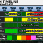
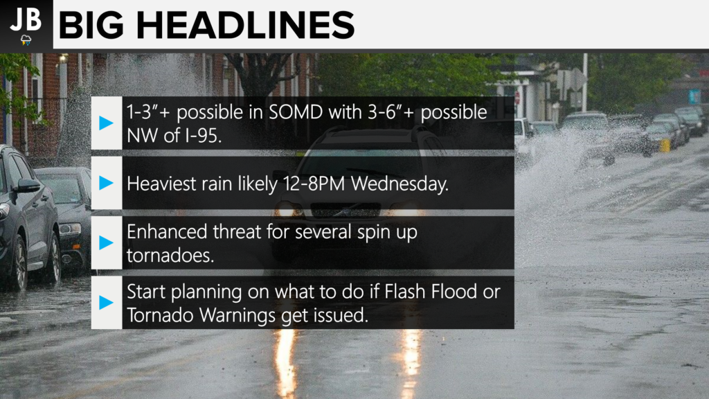
An impactful weather day remains on tap as the remnants of Hurricane Ida continue to work northward, and interact with an incoming cold front. The interaction between Ida and the front will enhance both a flooding and a tornado risk across the Mid-Atlantic and Northeast through tomorrow. The heaviest rain will be north of our region, across PA, NY, and Southern New England; but impactful totals are possible this afternoon in Southern MD. The bigger story locally for our region may be that we are the focal point for a tornado threat this afternoon. Wind gusts should be manageable, but the risk for some scattered power outages is present thanks to strong storms and very wet soil.
TIMING: We saw a Tornado Watch get issued overnight, which has been canceled as of 5AM, as an initial area of tropical moisture surged northward. Thankfully, much of that activity was kept to our north and west. Southern MD looks to stay dry through the morning and early afternoon hours. This will allow for warming to take place, which could help set off multiple rounds of storms this afternoon and evening. These storms will be able to put down 1-3″ of rain quickly, which could lead to flooding. We could also see embedded areas of rotation with this line as well. Clearing should take place overnight, with much of the activity out of here by sunrise Thursday.
Our Chesapeake’s Bounty Futurecast model does a great job of highlighting all of this down below.
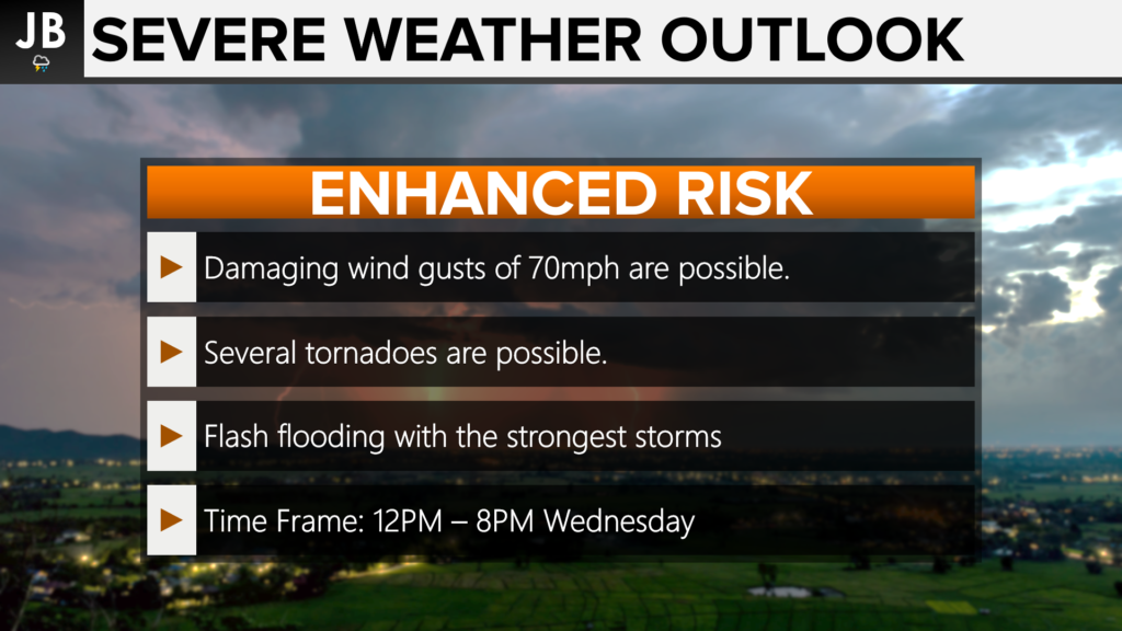
TORNADO THREAT: The break in the activity this morning into the early afternoon hours will allow for many areas to warm up into the 80s. This warmth, along with the tropical humidity, will help to make the atmosphere unstable and generate thunderstorm fuel. This added instability, combined with the large-scale twisting and turning of the winds throughout the Mid-Atlantic thanks to Ida, will lead to an ENHANCED RISK (Level 3 of 5) of severe storms this afternoon. These Enhanced Risks are not that common, and we normally only see about 2-4 of these outlooks get issued a year.
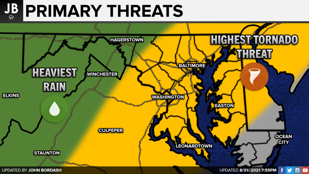
We saw on the Futurecast above that multiple lines of storms may try to work through the region between 12-8PM. Each of these lines will have the ability to tap into the atmospheric fuel and large-scale turning of the winds to produce strong storms capable of rotation. The most likely area for this to occur will be east of mountains to the Atlantic Beaches. This threat includes ALL of our region.
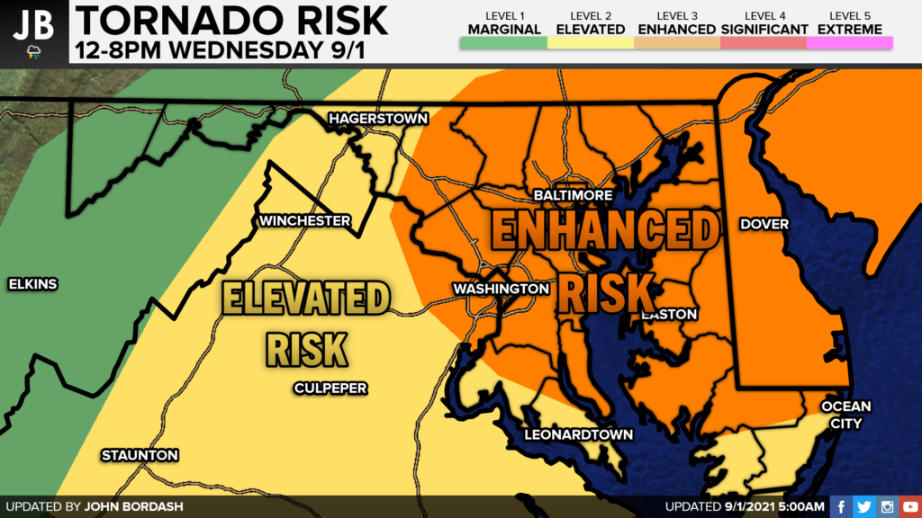
This threat is largely driven due to the high tornado threat. The probability we see a tornado in our region today is around 10%. While this threat does not seem high, it is 20-40 times higher than the typical tornado threat we have on any given day of the year. These 10% risk days are very few and far between, typically only getting issued once every other year in our area. It is important to note that the risk is not 100%. Not everyone will see a tornado. We may only see 1 or 2 rotating storms in the Mid-Atlantic, and they could happen anywhere.
These severe weather outlooks are not a promise of storms. They are to alert you to the potential of severe weather. Meteorology is far from a perfect science, and we will need to closely watch where these storms do end up setting up. Again, while the highest threat probability is in the orange shaded region, all zones have a heightened tornado threat that we do not typically see. The time to be especially vigilant would be between 12-8PM today.
FLOODING THREAT: Heavy rain continues to be a concern for the entire Mid-Atlantic and Northeast. A rare EXTREME RISK (Level 4 of 4) of flash flooding has been issued across much of Pennsylvania, New York, and southern New England. This is where the rain totals will be the highest, potentially getting to near 5-8″+. Widespread life-threatening floods will be likely in this region.
Much of our local region remains under an Elevated to Significant Risk of flash flooding this afternoon. This means that there is a heightened threat for flash flooding to occur in flood-prone areas/towns, and along rivers, creeks, and streams. A couple of areas could see significant and life-threatening flash flooding as afternoon storms could drop 1-3″ in just a couple of hours.
While southern areas may “just” be under an Elevated Risk, that threat category is still rather worrisome. We start each day at Level 0, so the fact that this area is up to a Level 2 is remarkable. Do not build a false sense of security because you are not in the pink or the red zones. Areas in the yellow zones WILL see flooding take place as well!
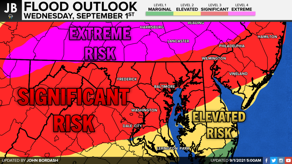
For the last few days, we have been highlighting the area north and west of I-95 to see the highest rain totals, and not much has changed there. Those regions could see 3-6″+ of rain throughout the day. That region is where the rain will be more consistent throughout the day.
Lower, but still impressive, totals will be found in our region. I think the potential is there for Southern Maryland to see 1-3″ of rain. Some communities will fail to reach that 1″ mark, and others may see more than 3″. This forecast is to give you a general idea of what to expect. It is near impossible to pinpoint exactly which areas will overperform and which areas will underperform. All it takes is for one, or multiple, slow-moving storms to impact your community for you to get in that 2-3″+ range.
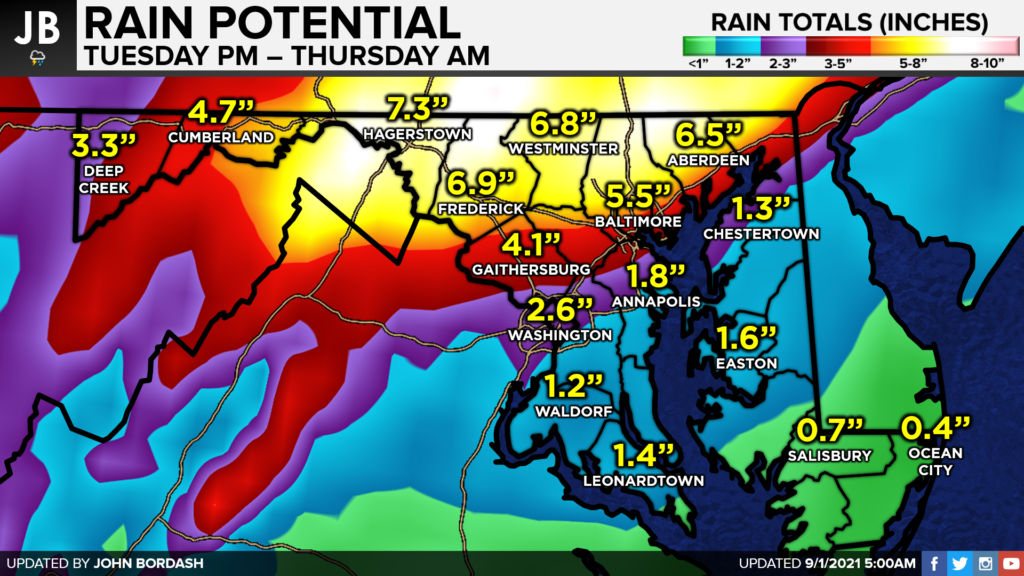
SUMMARY: Today will be a high-impact weather day, which is why JB Weather is in weather alert mode through tonight! 1-3″ of rain may fall this afternoon, with 3-6″+ falling northwest of DC. The heaviest of our rain today in Southern MD will likely occur between 12-8PM. That is when multiple lines of storms will look to move through our region. These lines will have the ability to have embedded storms that will be very prone to rotate. That heightened tornado threat is really focused on our region, so we will need to pay especially careful attention this afternoon.
Have a game plan of what you will do if your area gets placed under a Flash Flood Warning or a Tornado Warning. Consider these questions:
- What alternate routes home can you take?
- What schedule alterations can you make?
- Where will you go if a dangerous storm is overhead?
- What items will you bring with you if you are in a weather emergencysituation?
- Where is the closest substantial shelter near your home, school, or work?
- What ways will you be able to get weather updates? (We know the answer is JB Weather!)
- If you have to seek higher ground, where will you go?
I do not say all of this to worry you! But it is important to start thinking about the answers to these questions so you can act in a high-stress and high-impact weather situation.
It will be important to stay with JB Weather for the latest information on Ida and her important impacts here in Southern Maryland. You can always access my forecasts and updates here on the website, on Facebook, on Twitter, and on YouTube. JB Weather is Southern Maryland’s Weather Leader, and I am working around the clock to keep you ahead of the storm!
-JB

Dugan, McKissick & Longmore, LLC has served our Southern Maryland community for over 25 years. Our trusted attorneys are here to handle your unique case from beginning to end. To schedule an appointment, call us today at 301-862-3764 or visit our website at www.paxlawyers.com.
John Bordash
View More PostsJB Weather forecaster John Bordash is working around the clock to provide Southern Maryland, and neighboring communities, with accurate and reliable weather information.