Brought to you by William Richmond Inc. Roofing & Siding
We have a rather active Tuesday on tap as a powerful and high-impact is set to move through the region. Flooding rain, damaging winds, and tidal water rise are all likely. We will likely see conditions deteriorate after sunrise tomorrow. The highest impacts are likely to come Tuesday afternoon and evening.
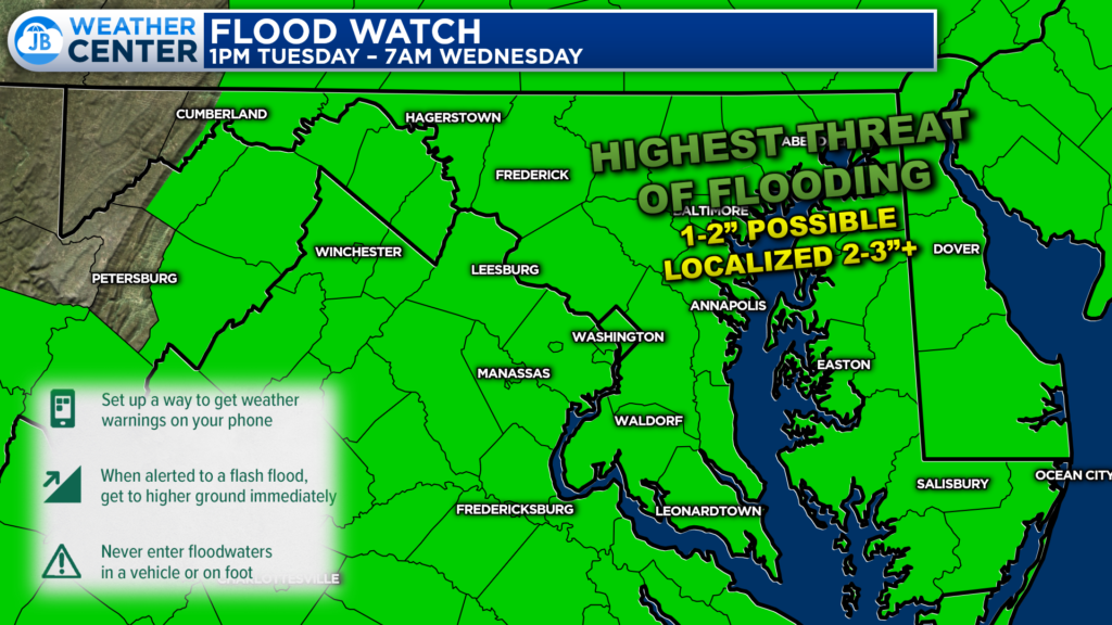
Off the bat, Flood Watches have been issued areawide for tomorrow afternoon and evening. Periods of heavy rain are likely to move through. Localized downpours could drop a significant amount of rain in a sort period of time. Given our recent deluge of storms, it will not take much to cause flooding.

Urban areas along I-95 will be the most prone to flash flooding. As a result, an uncommon Level 3 out of 4, “Significant Risk” of flash flooding, has been hoisted in that area. However, many locations will likely have that elevated threat of flash flooding through tomorrow night.

Many of our weather models like the idea of dropping a general 1-2″ of rain tomorrow. I could see localized pockets of 2-3″ amounts where heavy rain consistently trains. This will likely create traffic headaches, especially for the evening commute. Expect delays and possible road closures.
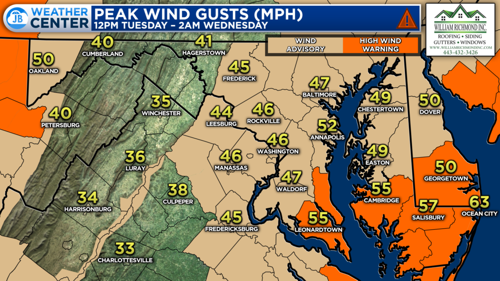
Winds will also be a threat thanks to the strong southeasterly flow. We could see winds gust up to 40-50mph for much of the region. However, our Bayside locations could see locally higher gusts up to 60mph. As a result. High Wind Warnings have been hoisted for Calvert & St. Mary’s Counties from 3PM Tuesday through 1AM Wednesday.
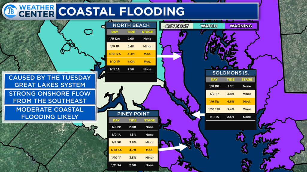
The strong onshore flow will also create a high coastal flooding threat. Sensitive areas along the Bay and major rivers, such as North Beach, Solomons, and Piney Point, will likely see moderate impacts thanks to 2-4 foot tidal levels.
– North Beach: At 4.0 feet, portions of 7th, 8th, and 9th Streets will flood, with homes affected near 9th Street.
– St. George Island: At 3.5 feet, water covers roads on Saint George Island, is in yards, and is approaching structures. To the east, inundation is occurring at multiple marinas off St. Mary`s River, Smith Creek, and Jutland Creek.
– Solomons: At 4.0 feet, flooding of structures near Charles Street in Solomons is possible. Yards, parking lots, and portions of both Charles and Williams Street are covered by more than a foot of water.
Needless to say, tomorrow is likely to bring high impacts to the region. Be especially aware of impacts peaking in the afternoon and evening hours. Rain, wind, and coastal flooding will be threats that are at play. Stay with JB Weather for the latest information on impacts here in Southern Maryland. You can always access my forecasts and updates here on the website, on Facebook, on Twitter, and on YouTube. JB Weather is Southern Maryland’s Weather Leader, and I am working around the clock to keep you ahead of any storm!
-JB

William Richmond Inc. is your trusted roofing and siding contractor in Southern Maryland. Our services include roof installation and repair, siding replacement, gutter installation and repair, and window replacement. Contact us today for quality workmanship and exceptional customer service.
John Bordash
View More PostsJB Weather forecaster John Bordash is working around the clock to provide Southern Maryland, and neighboring communities, with accurate and reliable weather information.