Brought to you by William Richmond Inc. Roofing & Siding
The National Weather Service is now highlighting that our coastal storm is strengthening faster than earlier projections, with increasing concern for heavier snow and potential blizzard conditions tonight. This marks a notable escalation in the forecast as impacts begin ramping up across the Mid-Atlantic.
CURRENT CONDITIONS
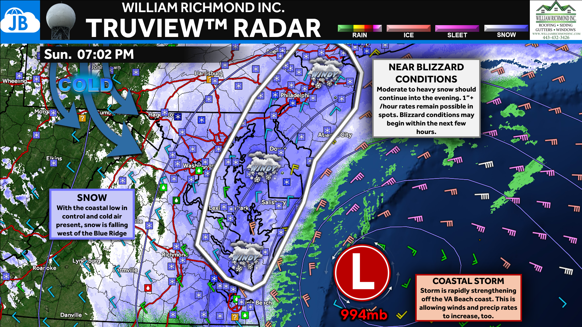
Snow has already been falling for several hours east of I-95, with many locations reporting 1–3 inches so far as the coastal low strengthens offshore. The newly issued Mesoscale Discussion highlights that the storm is intensifying and may begin producing more widespread heavy snow this evening. Forecasters note that snowfall rates exceeding 1 inch per hour are increasingly likely within developing bands from eastern Maryland through Delaware and New Jersey, extending into Tidewater Virginia. This represents an upgrade in expectations, signaling a transition from steady snowfall to potentially more impactful conditions.
FUTUREVIEW: LOOKING AHEAD
Overnight, continued strengthening of the coastal low will allow both snowfall intensity and winds to increase. The tightening pressure gradient along the coast could produce areas of blowing snow and sharply reduced visibility, with blizzard conditions possible in parts of the coastal Mid-Atlantic. The highest impacts remain most likely east of the Chesapeake Bay and along the coastal plain, where both heavier snow bands and stronger winds are favored. Farther inland, snow will persist but with somewhat lower rates and reduced wind impacts.
PUTTING IT ALL TOGETHER

Moving forward, the key focus will be where the heaviest snow bands set up and how quickly winds increase overnight. The new Mesoscale Discussion makes clear that impacts could ramp up faster than previously expected, especially near the coast. Travel conditions will deteriorate through the night, with visibility and road conditions worsening as snowfall rates increase. We will continue monitoring radar trends and observations closely as the storm reaches peak intensity.
KEY TAKEAWAYS
- ⚠️ New NWS Mesoscale Discussion signals an upgrade in storm intensity
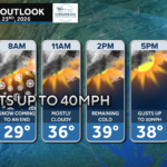
- ❄️ Heavier snow bands likely this evening with 1″+/hour rates possible
- 🌬️ Winds increase overnight with blowing snow and visibility issues
- 📍 Greatest impacts expected east of the Bay and along the coast
Stay with JB Weather for the latest information on impacts here in Southern Maryland and across the Mid-Atlantic. You can always access my forecasts and updates here on the website, on Facebook, on Twitter, on Instagram, and on YouTube. JB Weather is the Mid-Atlantic’s Weather Leader, and I am working around the clock to keep you ahead of any storm!

William Richmond Inc. is your trusted roofing and siding contractor in Southern Maryland. Our services include roof installation and repair, siding replacement, gutter installation and repair, and window replacement. Contact us today for quality workmanship and exceptional customer service.
John Bordash
View More PostsJB Weather forecaster John Bordash is working around the clock to provide Southern Maryland, and neighboring communities, with accurate and reliable weather information.