Brought to you by Cedar Point Federal Credit Union
With the storm now complete, we can step back and evaluate how this complex winter system unfolded — and how the Final Snow Call verified.
As expected, this event quickly evolved into a classic mixed-precipitation storm, with snow giving way to sleet and pockets of freezing rain as warmer air surged aloft. The key takeaway from the observed data is that sleet was the dominant ice contributor, not freezing rain. While freezing rain did occur and did accrete — generally topping out around 0.15–0.20 inches in the hardest-hit areas — its impact was limited by how long much of the region remained locked into sleet. That prolonged sleet phase capped glaze accretion on trees and power lines, but still created extremely hazardous travel conditions as dense ice pellets piled on top of existing snow. This also explains why impacts were widespread on roads and sidewalks, yet structural icing remained somewhat less severe than worst-case outcomes.
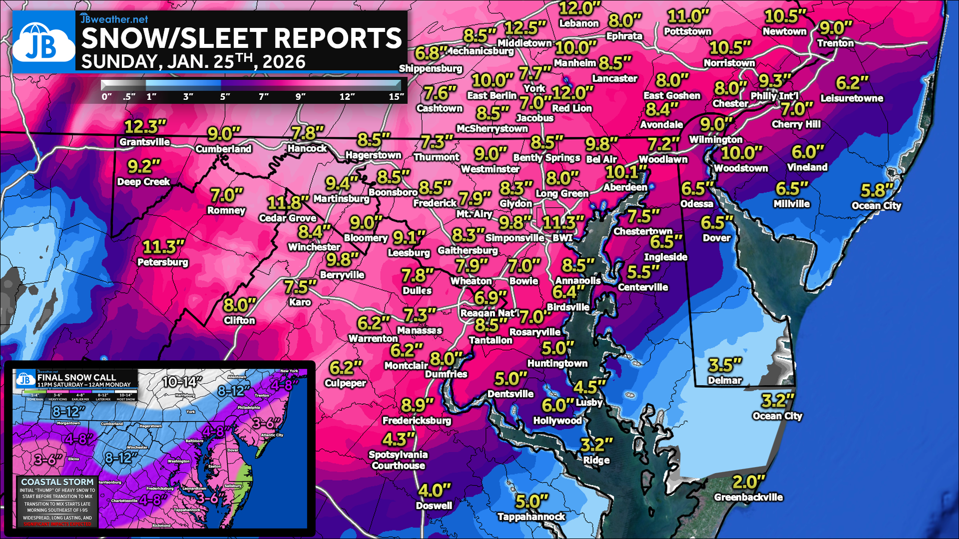
When comparing these results to the Final Snow Call, the forecast verified strongly in both placement and overall totals, especially considering the storm’s narrow thermal margins. The anticipated northwest-to-southeast gradient verified well, with 8–12″ totals northwest of I-95 and 4–8″ (locally lower) southeast, where earlier mixing occurred. Messaging correctly highlighted sleet as a major player, which is reflected in the final reports that combine snow and sleet — a detail that may cause totals to appear high to casual observers. While power outages did occur, they ultimately verified as isolated to scattered rather than widespread, consistent with the sleet-dominated outcome limiting ice loading on infrastructure. Minor background shading discrepancies are due to a NOHRSC alignment issue and do not affect the point data. Taking forecast accuracy, impact messaging, and outcome realism into account, this forecast earns a strong B+ to A- — especially for a storm where small temperature differences had outsized consequences.
The following are unofficial observations taken during the past 36
hours for the storm that has been affecting our region. Appreciation
is extended to cooperative and CoCoRaHS observers, Skywarn spotters
and media for these reports. This summary also is available on our
home page at weather.gov/baltimore

**********STORM TOTAL SNOWFALL (AT LEAST 0.1 INCH)**********

LOCATION                TOTAL      TIME/DATE  COMMENTS
                     SNOWFALL       MEASURED
                     (inches)

DISTRICT OF COLUMBIA

...District of Columbia...
  Washington 3 NE         7.5   717 PM  1/25  Social Media

MARYLAND

...Allegany County...
  Ridgeley 1 NW           9.0   700 AM  1/26  Trained Spotter
  Cumberland              8.6   700 PM  1/25  Co-Op Observer
  Frostburg               7.6   700 AM  1/26  Co-Op Observer
  Frostburg 2 ENE         7.5   539 PM  1/25  Trained Spotter
  La Vale                 6.9   900 PM  1/25  Trained Spotter

...Anne Arundel County...
  Bwi Airport            11.3  1200 AM  1/26  Official NWS Obs
  Green Haven 1 ESE      10.2   600 AM  1/26  Trained Spotter
  Crofton 1 SSE           9.5   947 PM  1/25  NWS Employee
  Londontowne 1 SSE       9.4   902 PM  1/25  NWS Employee
  Crownsville 3 SSW       8.5   930 PM  1/25  Trained Spotter
  Pasadena 1 ENE          8.5   745 PM  1/25  Trained Spotter
  Chelsea Beach           7.8   559 PM  1/25  Trained Spotter
  Riva  ESE               7.2   415 PM  1/25  Trained Spotter

...Baltimore County...
  Bentley Springs 6 S    11.3   715 PM  1/25  Dept of Highways
  Edgemere  SE           10.3   720 PM  1/25  Trained Spotter
  Upper Falls 2 SW        9.8   900 PM  1/25  Trained Spotter
  Reistertown 2 NW        9.5  1000 PM  1/25  Co-Op Observer
  Middle River 1 N        9.0   822 PM  1/25  Trained Spotter
  Bentley Springs 1 E     8.5   645 PM  1/25  Trained Spotter
  Glyndon 1 WSW           8.3   550 PM  1/25  Trained Spotter
  Long Green 2 NW         8.0   530 PM  1/25  Trained Spotter
  Upper Falls 1 NNE       7.9   815 PM  1/25  Trained Spotter

...Baltimore City...
  Arlington 2 ESE         8.6   615 PM  1/25  Broadcast Media
  Arlington 2 E           8.5   820 PM  1/25  Broadcast Media

...Calvert County...
  Prince Frederick 1 S    5.5   650 PM  1/25  Trained Spotter
  Huntingtown             5.0   405 PM  1/25  Amateur Radio
  Chesapeake Beach 3 S    5.0   718 PM  1/25  Amateur Radio
  Lusby                   4.0   406 PM  1/25  Amateur Radio

...Carroll County...
  Winfield  N            11.5   900 PM  1/25  Trained Spotter
  Watersville 1 N         9.5   900 PM  1/25  Trained Spotter
  Westminster 1 NNE       9.0   716 PM  1/25  Dept of Highways
  Gamber 1 WNW            8.2  1029 PM  1/25  CoCoRaHS
  Westminster  SE         8.0   811 PM  1/25  Trained Spotter

...Cecil County...
  Pleasant Hill 2 SE      7.5   730 PM  1/25  Trained Spotter
  Fair Hill 1 SW          7.5  1159 PM  1/25  Trained Spotter
  Woodlawn 2 ENE          7.2   525 PM  1/25  Trained Spotter
  Rock Springs 1 ESE      6.5   600 PM  1/25  Trained Spotter

...Charles County...
  Dentsville 1 SW         5.0   430 PM  1/25  Trained Spotter

...Frederick County...
  Sabillasville 2 SSE    13.0   900 AM  1/26  Trained Spotter
  Bloomfield 2 WSW       10.2   500 PM  1/25  NWS Employee
  New Market  N           9.5   756 PM  1/25  Trained Spotter
  Smithsburg 3 SE         8.5   642 PM  1/25  Trained Spotter
  Adamstown 1 ESE         8.3   630 PM  1/25  NWS Employee
  Frederick 1 ESE         8.0   900 AM  1/26  Trained Spotter
  Point of Rocks 1 NE     8.0   930 PM  1/25  Trained Spotter
  Mount Airy 1 SW         7.9   730 PM  1/25  Trained Spotter
  Thurmont 1 NE           7.0   440 PM  1/25  Trained Spotter
  Myersville 3 ESE        7.0   502 PM  1/25  Trained Spotter

...Garrett County...
  Deer Park 6 NE         13.0  1000 AM  1/26  Trained Spotter
  Grantsville 5 W        12.3   500 AM  1/26  Dept of Highways
  Accident 4 E           10.7   644 PM  1/25  Public
  Oakland 5 NW            9.3   741 AM  1/26  Trained Spotter
  Mount Savage 4 WNW      9.0   640 PM  1/25  Trained Spotter
  Deer Park 4 NNE         8.8   700 AM  1/26  Trained Spotter

...Harford County...
  Abingdon 2 NW          10.8   719 AM  1/26  Trained Spotter
  Bel Air 2 E            10.5   700 AM  1/26  Trained Spotter
  Aberdeen Proving Gro   10.1   816 PM  1/25  Trained Spotter
  Forest Hill 2 SW       10.1   715 PM  1/25  Trained Spotter
  Bel Air 2 NE            9.8   709 PM  1/25  Broadcast Media
  Chrome Hill 2 SE        9.8   820 PM  1/25  Trained Spotter
  Bynum 1 NNE             9.2   457 PM  1/25  Trained Spotter
  Jarrettsville           9.0   518 PM  1/25  Local Official
  Bel Air 3 SSE           9.0   500 PM  1/25  Trained Spotter
  West Friendship 2 NW    7.8   705 PM  1/25  Trained Spotter
  Gaither 2 SSE           7.4   625 PM  1/25  Trained Spotter
  Scarboro 2 E            7.0   835 PM  1/25  Trained Spotter

...Howard County...
  Simpsonville           11.3  1126 PM  1/25  Trained Spotter
  Simpsonville  E        11.3   750 PM  1/25  Trained Spotter
  Granite 1 SSE          11.1   600 PM  1/25  Trained Spotter
  Clarksville 3 NE       11.1   837 PM  1/25  NWS Employee
  Columbia               10.6   800 PM  1/25  NWS Employee
  Gaither 2 SE            9.8   900 PM  1/25  Trained Spotter
  Simpsonville 1 SSE      9.8  1000 PM  1/25  Trained Spotter
  Elkridge 2 W            9.5   745 PM  1/25  Trained Spotter
  Clarksville 2 N         9.2   900 PM  1/25  Trained Spotter
  Historic Ellicott Ci    9.2   902 PM  1/25  NWS Employee
  Laurel 1 NNE            9.1   530 PM  1/25  CoCoRaHS
  Dayton 1 NE             9.0   716 PM  1/25  Dept of Highways
  Laurel 3 NNE            8.8   839 PM  1/25  Trained Spotter
  Gaither 2 SSW           8.0   700 PM  1/25  Trained Spotter
  Elkridge 2 ESE          7.6   708 PM  1/25  Trained Spotter
  Highland 2 WNW          7.6   830 PM  1/25  NWS Employee
  Ellicott City           7.5   748 PM  1/25  Broadcast Media
  Ellicott City 1 SW      7.3   835 AM  1/26  Trained Spotter
  Columbia 1 ENE          7.0   500 PM  1/25  Trained Spotter

...Montgomery County...
  Clarksburg             11.8   836 PM  1/25  Emergency Mngr
  Clarksburg 2 SE        11.6   811 PM  1/25  Public
  Germantown              9.2   525 PM  1/25  Emergency Mngr
  Somerset 1 ENE          9.0   700 PM  1/25  Trained Spotter
  Rockville 1 SSE         8.8   900 PM  1/25  Trained Spotter
  Laytonsville 2 WNW      8.8   815 PM  1/25  Trained Spotter
  Germantown 1 SE         8.5  1127 PM  1/25  Trained Spotter
  Gaithersburg 2 E        8.5   630 PM  1/25  NWS Employee
  Brookeville 2 NW        8.1   820 PM  1/25  Trained Spotter
  Laytonsville            8.0   351 PM  1/25  Emergency Mngr
  Damascus 3 SSW          8.0   551 PM  1/25  Co-Op Observer
  Rockville               7.9   813 PM  1/25  NWS Employee
  Wheaton 1 NW            7.9   800 PM  1/25  Trained Spotter
  Olney 1 S               7.5   830 PM  1/25  Trained Spotter
  Gaithersburg 1 SW       7.4   829 PM  1/25  Trained Spotter
  Norbeck 1 ESE           7.2   700 AM  1/26  Trained Spotter
  Bethesda 1 NNW          7.0   829 PM  1/25  Trained Spotter
  Poolesville  NE         7.0   506 PM  1/25  Trained Spotter
  Boyds 1 SE              6.8   615 PM  1/25  Trained Spotter
  Potomac 2 NW            6.7   408 PM  1/25  Emergency Mngr
  Garrett Park 1 WSW      6.6   912 PM  1/25  Trained Spotter
  Silver Spring           6.5   617 PM  1/25  NWS Employee
  Colesville 2 WNW        6.3   410 PM  1/25  Emergency Mngr

...Prince Georges County...
  Brentwood 1 SSW         9.0   503 PM  1/25  Trained Spotter
  Marlton 1 WSW           7.0   830 PM  1/25  Trained Spotter
  Forestville             7.0   407 PM  1/25  Amateur Radio
  Bowie 2 SSE             7.0  1033 PM  1/25  NWS Employee
  Laurel 2 SSW            6.6   345 PM  1/25  Social Media
  College Park 1 S        6.6   700 PM  1/25  Trained Spotter

...St. Marys County...
  California              4.0   406 PM  1/25  Amateur Radio
  Ridge 1 E               3.2   500 PM  1/25  Trained Spotter

...Washington County...
  Sabillasville 2 NNW     9.3   704 PM  1/25  CoCoRaHS
  Boonsboro 3 NNE         9.1   700 PM  1/25  Trained Spotter
  Boonsboro 1 SSE         8.5   630 PM  1/25  Trained Spotter
  Maugansville  WSW       8.5   700 AM  1/26  Trained Spotter
  Funkstown 2 WSW         8.0   430 PM  1/25  Dept of Highways
  Hancock 1 ESE           7.8   730 PM  1/25  Trained Spotter

VIRGINIA

...Albemarle County...
  Earlysville 3 NW        6.5   900 PM  1/25  Trained Spotter
  Charlottesville 2 W     5.9   800 AM  1/26  Co-Op Observer
  Boyd Tavern 1 S         5.2   430 PM  1/25  Trained Spotter
  Overton 3 NW            5.0   826 AM  1/26  Trained Spotter

...Arlington County...
  Falls Church 1 E        8.5   645 PM  1/25  NWS Employee
  Ballston                7.5   446 PM  1/25  Trained Spotter
  Reagan National Apt     6.9  1200 AM  1/26  Official NWS Obs
  Baileys Crossroads 1    6.8   820 PM  1/25  Trained Spotter

...Augusta County...
  Mint Spring 3 SSE       5.1   830 AM  1/26  Trained Spotter

...City of Charlottesville...
  Newcomb Hall 1 SW       5.3   551 PM  1/25  Trained Spotter

...City of Fairfax...
  Fairfax 1 N             7.0   815 PM  1/25  NWS Employee

...City of Waynesboro...
  Waynesboro 1 S          4.5   349 PM  1/25  Trained Spotter

...Clarke County...
  Berryville 1 NNW       10.3   700 AM  1/26  CoCoRaHS

...Culpeper County...
  Culpeper 1 W            5.0   445 PM  1/25  Trained Spotter

...Fairfax County...
  Rose Hill  ENE          8.5   600 PM  1/25  Trained Spotter
  Vienna                  8.5   700 AM  1/26  Co-Op Observer
  Tantallon 2 W           8.5   501 PM  1/25  Trained Spotter
  Herndon 1 NNE           8.2   700 PM  1/25  NWS Employee
  Chantilly 1 SE          8.0   525 PM  1/25  Trained Spotter
  West Springfield 2 W    7.5   440 PM  1/25  Trained Spotter
  Woolsey 4 ENE           7.3   738 PM  1/25  NWS Employee
  Sterling Park 2 ENE     7.0   857 PM  1/25  Trained Spotter
  Herndon 2 ENE           7.0  1225 AM  1/26  Trained Spotter
  Chantilly 2 ESE         6.6   600 PM  1/25  Trained Spotter
  Centreville  W          6.5   855 PM  1/25  Trained Spotter
  Vienna  NNE             6.3   630 AM  1/26  Trained Spotter
  Fairfax Station 1 SE    5.5   820 PM  1/25  Trained Spotter

...Fauquier County...
  Warrenton               6.2   940 PM  1/25  Trained Spotter

...Frederick County...
  Cedar Grove 2 ENE      11.8   903 PM  1/25  Trained Spotter
  Hayfield 1 N            8.5   352 PM  1/25  Trained Spotter
  Cross Junction 1 SW     7.3   757 AM  1/26  Trained Spotter

...Greene County...
  Ruckersville 1 WNW      5.1   638 PM  1/25  Trained Spotter

...Highland County...
  Mill Gap 1 SW           6.8   700 AM  1/26  Co-Op Observer
  Mustoe                  6.0   700 AM  1/26  CoCoRaHS

...Loudoun County...
  Ashburn 1 W             9.8   700 PM  1/25  NWS Employee
  Leesburg 1 ESE          9.5   700 PM  1/25  ARTCC Leesburg
  Leesburg                9.1   523 PM  1/25  NWS Office
  Bloomery 3 ESE          9.0   630 PM  1/25  Trained Spotter
  Leesburg 1 E            9.0   900 PM  1/25  NWS Employee
  Ashburn  N              8.3   730 PM  1/25  Trained Spotter
  Countryside 3 ESE       8.0   930 AM  1/26  Trained Spotter
  Dulles International    7.8  1200 AM  1/26  Official NWS Obs
  Purcellville            7.7   700 AM  1/26  Co-Op Observer
  Leesburg 2 NNE          7.0   749 PM  1/25  Trained Spotter
  Sterling Park 1 E       6.5   800 AM  1/26  Trained Spotter

...Page County...
  Stanley 2 WSW           6.8   742 PM  1/25  Trained Spotter

...Prince William County...
  Manassas Park 1 NNW     9.0   730 PM  1/25  Trained Spotter
  Dumfries 1 ENE          8.0   403 PM  1/25  Trained Spotter
  Woodbridge              7.5   835 PM  1/25  Emergency Mngr
  Manassas Park 1 W       7.3   907 PM  1/25  Trained Spotter
  Bull Run 2 NE           7.0   558 PM  1/25  CoCoRaHS
  Woolsey 1 SW            6.6   635 PM  1/25  Trained Spotter
  Montclair 2 WNW         6.2   637 PM  1/25  Trained Spotter
  Haymarket               5.8   359 PM  1/25  Emergency Mngr

...Rockingham County...
  Broadway                7.5   600 PM  1/25  Broadcast Media
  Bridgewater 1 N         7.5   642 PM  1/25  Broadcast Media
  Harrisonburg            7.0   640 PM  1/25  Broadcast Media
  Linville 4 ENE          5.8   345 PM  1/25  Trained Spotter
  Timberville 3 NW        5.5   900 AM  1/26  Trained Spotter

...Shenandoah County...
  Mount Clifton 3 N       8.0   623 PM  1/25  Trained Spotter
  Toms Brook 3 SSE        7.0   445 PM  1/25  Trained Spotter
  Alonzaville 2 SE        6.0   745 AM  1/26  Trained Spotter
  Edinburg 2 E            5.5   642 PM  1/25  Trained Spotter

...Spotsylvania County...
  Massaponax 2 N         11.0   700 AM  1/26  CoCoRaHS
  White Oak 4 SSW         4.5   521 PM  1/25  NWS Employee
  Spotsylvania Courtho    4.3   759 PM  1/25  Trained Spotter

...Stafford County...
  Roseville 1 S          10.8   700 AM  1/26  CoCoRaHS
  Glendie 1 N             8.9   830 PM  1/25  Trained Spotter
  Holly Corner 2 E        8.9   733 PM  1/25  Trained Spotter

...Warren County...
  Karo 1 WSW              7.5   630 PM  1/25  Trained Spotter

WEST VIRGINIA

...Berkeley County...
  Martinsburg 6 E         9.4   855 PM  1/25  NWS Employee
  Winebrenners Cross 1    7.7   700 AM  1/26  CoCoRaHS
  Ridgeway 1 N            7.3   700 AM  1/26  CoCoRaHS
  Shepherdstown 4 NNW     7.0   435 PM  1/25  Trained Spotter
  Martinsburg             6.7   700 AM  1/26  Co-Op Observer

...Hampshire County...
  Romney  SW              7.0   600 PM  1/25  Trained Spotter

...Hardy County...
  Rig  NW                 7.1   800 PM  1/25  Trained Spotter

...Jefferson County...
  Millville 1 ESE         8.3   625 AM  1/26  Trained Spotter

...Mineral County...
  Hartmansville 1 E       8.0  1045 AM  1/26  Dept of Highways

...Pendleton County...
  Franklin 1 N            6.0   700 PM  1/25  Emergency Mngr
John Bordash
View More PostsJB Weather forecaster John Bordash is working around the clock to provide Southern Maryland, and neighboring communities, with accurate and reliable weather information.