Brought to you by Cedar Point Federal Credit Union
Our coastal storm is beginning to organize and strengthen offshore this afternoon, and we are now entering the phase where real-time radar trends matter more than model guidance. While the overall forecast remains on track, we are starting to see the details — including banding placement, wind strength, and timing — come into clearer focus as the storm develops.
CURRENT CONDITIONS
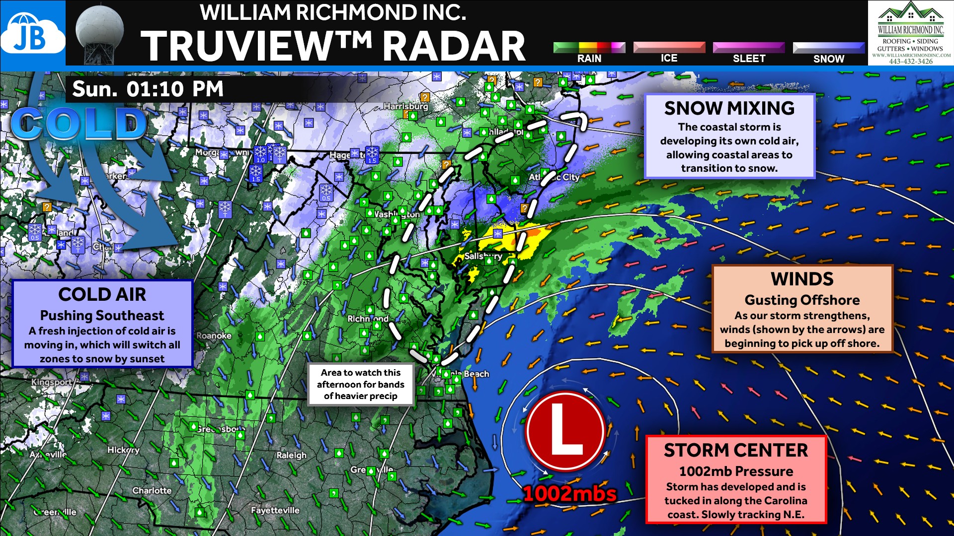
At this hour, radar shows precipitation overspreading the Mid-Atlantic, with rain still dominant in many areas but wet snow beginning to mix in as colder air gradually filters in. The coastal low has taken shape off the Carolina coast and will continue to intensify as it tracks northeast. Winds are already increasing offshore, and over the next several hours we’ll be watching Tidewater Virginia, Southern Maryland, Delmarva, and South Jersey closely for the first signs of heavier band development. Any bands that form there this afternoon could allow snowfall to begin accumulating earlier than expected in localized areas.
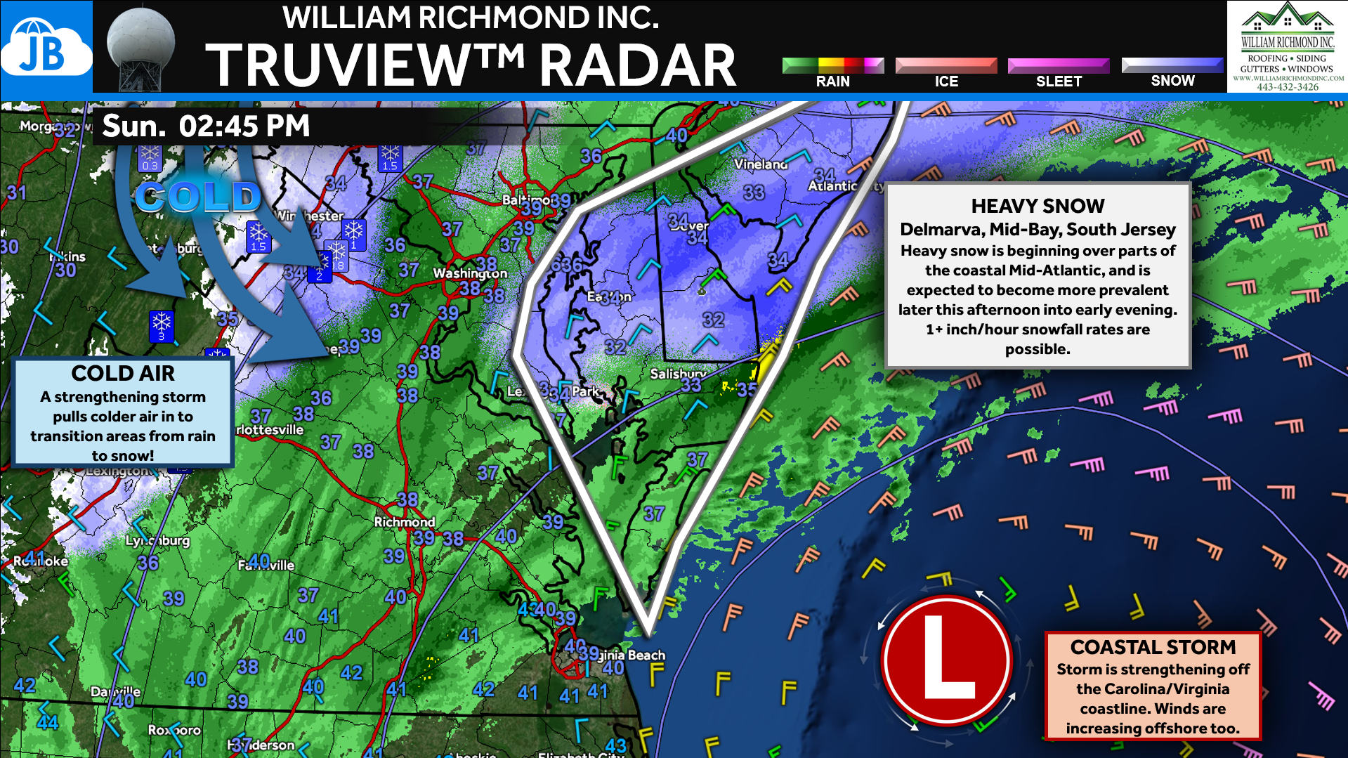
2:45PM UPDATE: The National Weather Service is highlighting Delmarva, Southern New Jersey, and parts of the Middle Bay — including Calvert and St. Mary’s Counties — as areas to watch for heavier snow bands over the next few hours.
STORM SETUP
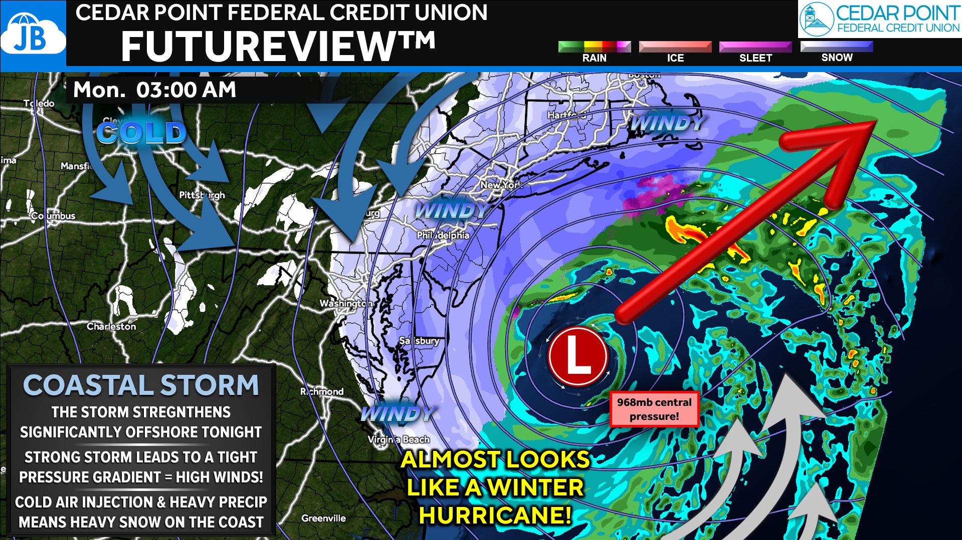
Looking ahead, our FutureView guidance continues to show the storm strengthening significantly tonight as it moves offshore, tightening the pressure gradient and producing both heavy snow and strong winds along the coast. While this system is not tropical, its projected central pressure near 968mb underscores just how powerful it will be.
FUTUREVIEW TIMING
Some modeling continues to hint at a subtle eastward shift in the track, which would keep the heaviest snow focused across Delmarva and coastal New Jersey while creating a sharper cutoff west of the Bay. This wouldn’t dramatically change the forecast, but it would favor the lower end of snowfall ranges in places like southern-central Pennsylvania and reinforce the tight gradient between I-95 and the Bay.
SNOWFALL FORECAST: REMAINS UNCHANGED
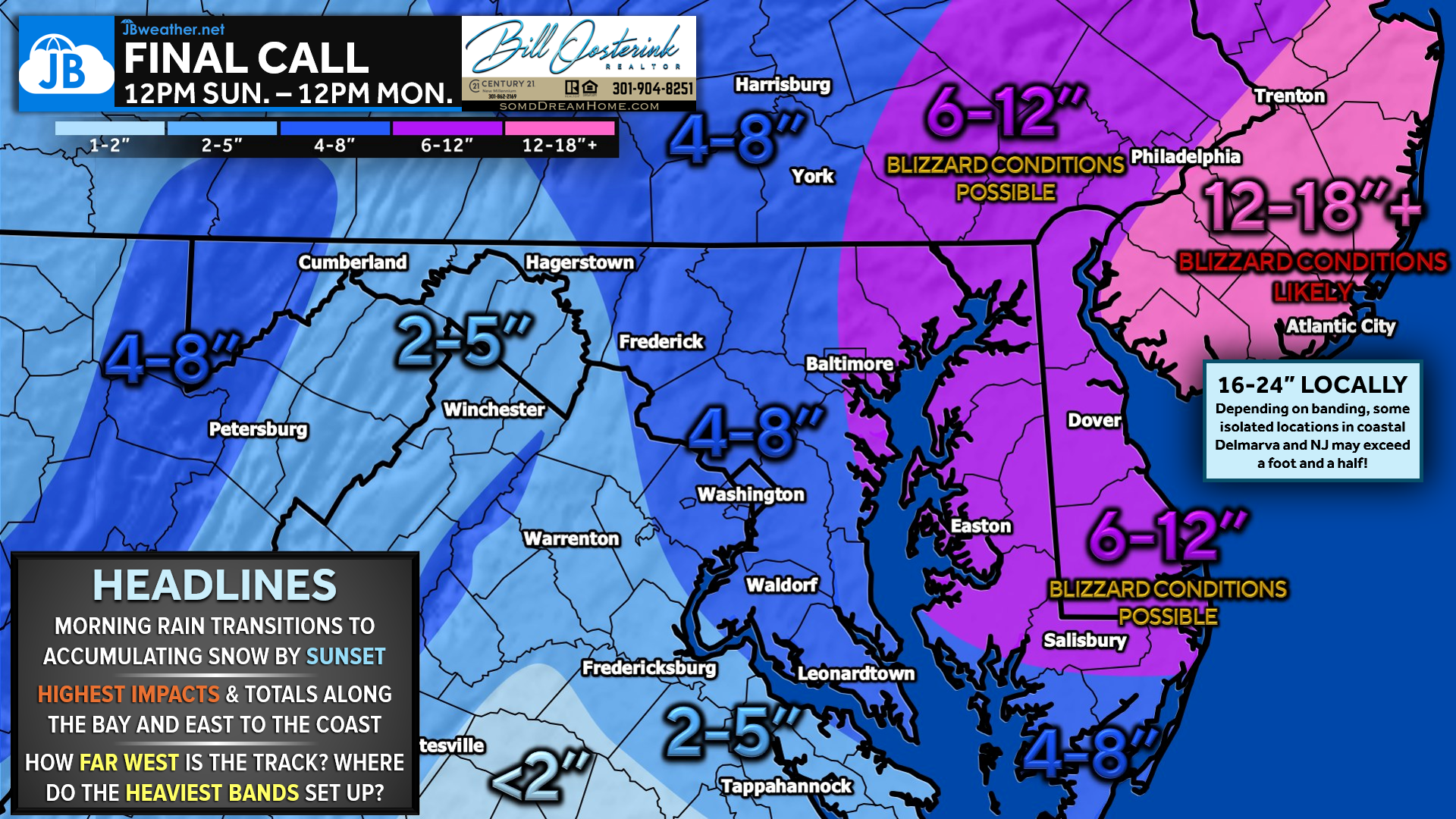
The snowfall forecast itself remains unchanged from earlier today. Snow should become widespread by sunset as colder air deepens and precipitation fully transitions from rain to snow. Current expectations still call for 4–8 inches between I-95 and the Bay, 6–12 inches across Delmarva, and 12–18 inches in New Jersey, with locally higher totals where the strongest bands set up. From here, it becomes a waiting game as radar trends reveal where those heavier bands ultimately lock in tonight.
PUTTING IT ALL TOGETHER
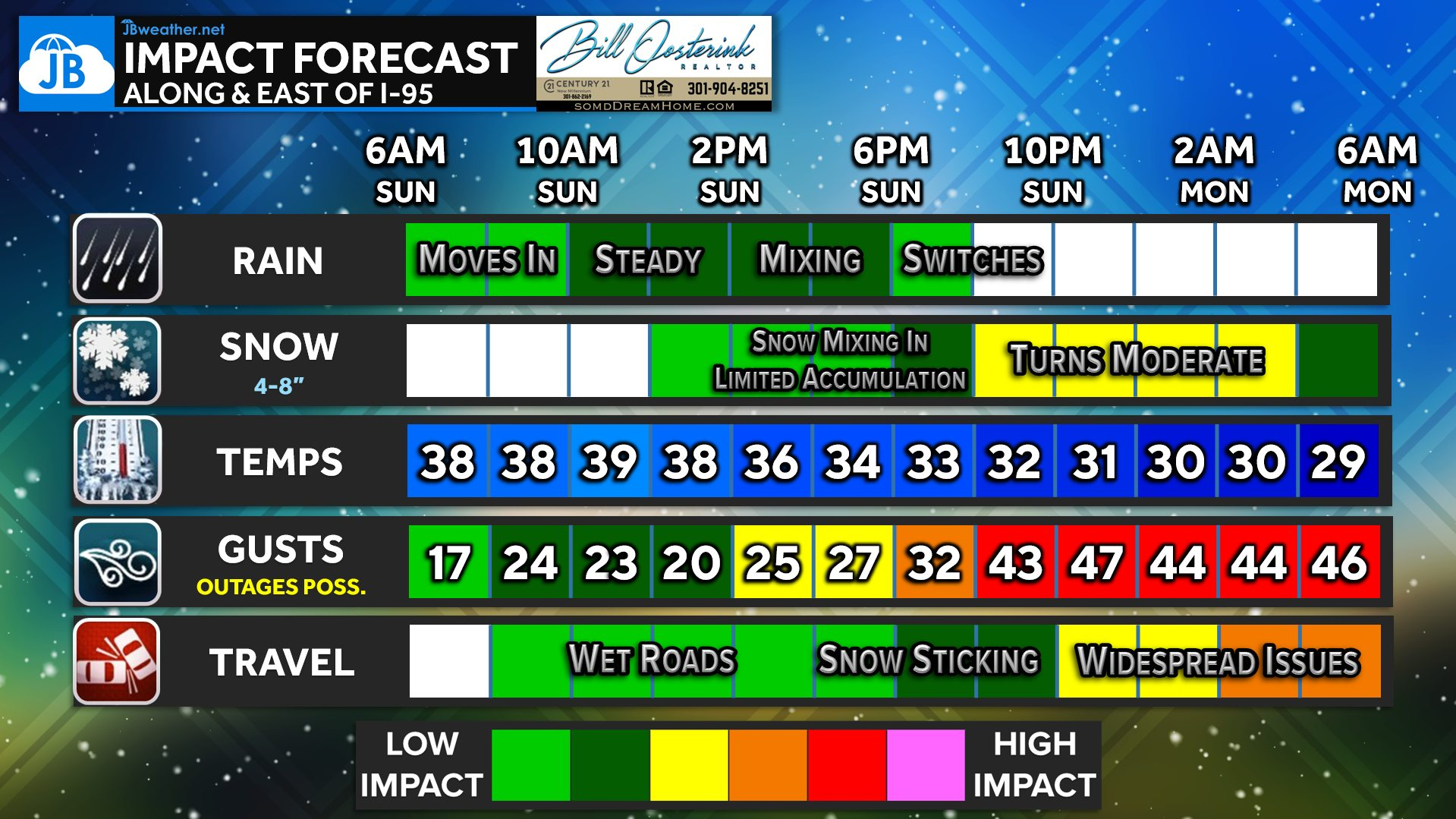
From this point forward, our focus shifts to real-time radar trends and where the heaviest snow bands ultimately set up tonight. Those bands will determine who sees the highest totals and where travel becomes most difficult overnight into Monday morning. Increasing winds along the coast will also lead to blowing snow and reduced visibility, especially where snow falls heavily. Conditions improve gradually Monday, but the overnight period will bring the most impactful weather.
4-BULLET SUMMARY
❄️ Snow becomes widespread by sunset with the heaviest accumulation overnight
🌬️ Strengthening storm brings increasing winds, especially along the coast
📍 Band placement tonight will determine where totals climb fastest
🚗 Travel conditions likely deteriorate overnight into Monday morning
Stay with JB Weather for the latest information on impacts here in Southern Maryland and across the Mid-Atlantic. You can always access my forecasts and updates here on the website, on Facebook, on Twitter, on Instagram, and on YouTube. JB Weather is the Mid-Atlantic’s Weather Leader, and I am working around the clock to keep you ahead of any storm!
Cedar Point has been providing trusted banking, lending and personal finance solutions to the Southern Maryland Community since 1945. Visit the credit union at any of its 6 locations in St. Mary’s, Charles and Calvert counties or online at www.cpfcu.com.
John Bordash
View More PostsJB Weather forecaster John Bordash is working around the clock to provide Southern Maryland, and neighboring communities, with accurate and reliable weather information.