Brought to you by Sonder Studios
This storm ultimately tracked and verified a bit farther east than expected, allowing intense coastal banding to dominate the snowfall pattern. The result was a jackpot along Delmarva and the coast, while totals dropped off much more quickly west of the Bay.
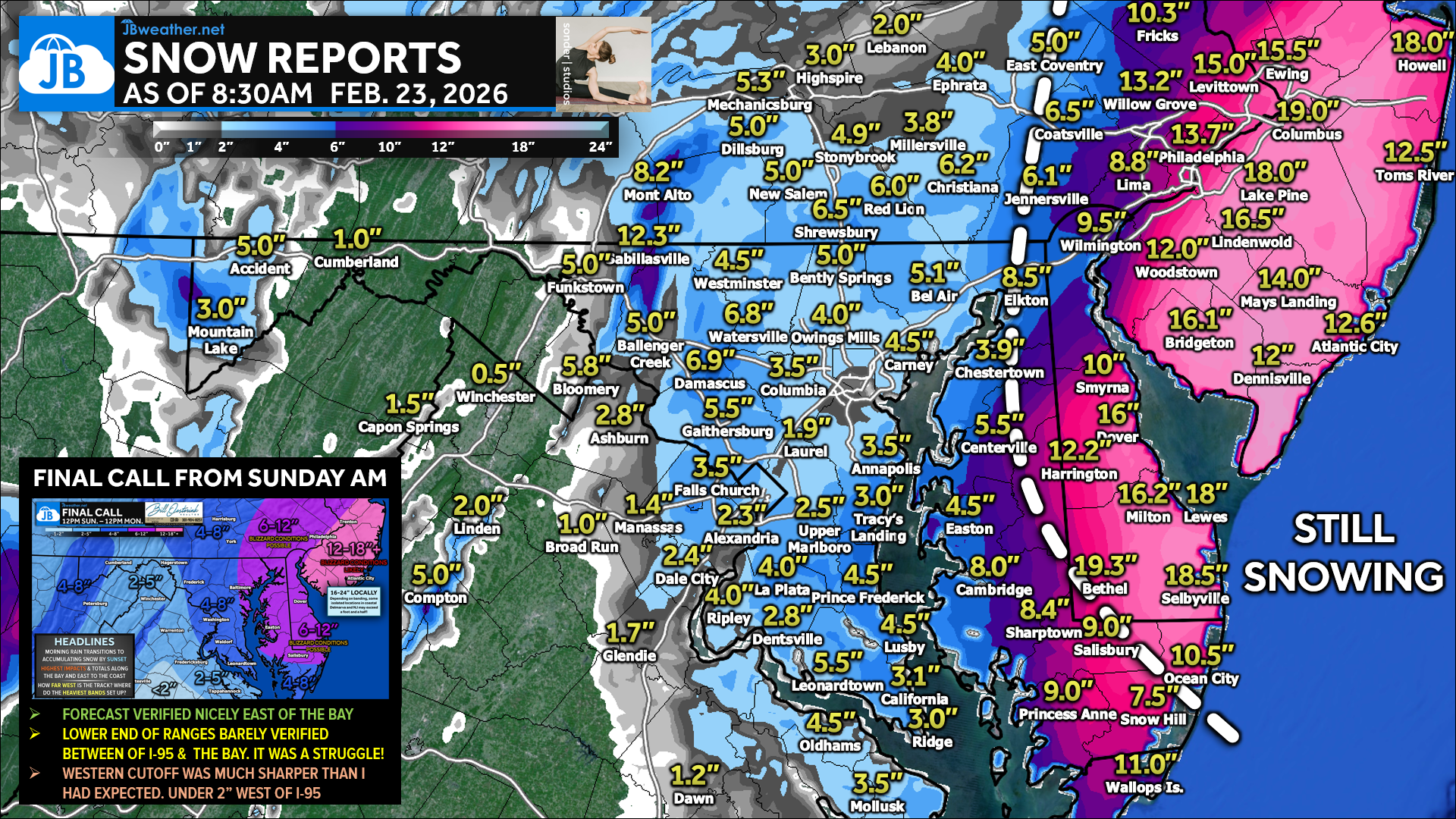
This morning’s snowfall reports are a textbook example of a coastal-based Nor’Easter. The jackpot set up from Delmarva into New Jersey, where the coastal banding did exactly what it was capable of.
- Widespread 12–20”+ totals with several big hits — 16.0” in Dover, 14–16” around Harrington/Smyrna, and near-blizzard snowfall rates driving totals up to 19.3” in Bethel, 19.0” near the Delaware Coastal Airport, and 18”+ around Lewes/Selbyville.
- Meanwhile, west of the Bay, totals were clearly more modest and much more variable: generally 2–6” for a lot of inland/eastern MD and central MD spots (with some localized higher amounts like 8.5” in Elkton and 6–7” reports in parts of Carroll/Montgomery).
- Much of Southern Maryland saw a general 3-5″ which was on the lower edge of the forecast range. Areas in Prince George’s and Anne Arundel saw a general 2-4″.
- And then there was a noticeable drop-off farther west where some communities struggled to get much accumulation at all.
Forecast-wise, the biggest storyline is that this storm’s best forcing and moisture axis stayed farther east, and the heavy deformation bands near the coast essentially “hogged” the moisture, preventing the snow shield from working as effectively farther inland. That’s why the western cut-off ended up sharper than expected, and why areas west of the Bay (and especially farther inland) saw lighter rates, more down time, and totals that leaned toward the low end (or even below it in spots). What still verified well was the overall message: the highest impacts were always going to be east of the Bay and toward the coast — the storm just ended up leaning even harder into that coastal solution than we anticipated.
CONCLUSION
This storm was a great example of how critical storm track and band placement are in winter forecasting. From early on, we highlighted the potential for the heaviest snow to stay closer to the coast, and that ultimately verified as the deformation band locked in along the shoreline and kept deeper moisture from pushing inland. While totals varied sharply across the region, the overall evolution of the storm followed the trends we had been monitoring for several days. Below is a look at reported snow totals!
********************STORM TOTAL SNOWFALL********************

LOCATION                TOTAL      TIME/DATE  COMMENTS
                     SNOWFALL       MEASURED
                     (inches)

DELAWARE

...Kent County...
Dover                        16.0 in   0645 AM 02/23   Public
Harrington                   14.3 in   0600 AM 02/23   Trained Spotter
Smyrna 3.5 SSW               13.2 in   0700 AM 02/23   COCORAHS
1 N Harrington               12.2 in   0202 AM 02/23   Trained Spotter
3 ENE Kenton                 11.5 in   1200 AM 02/23   Cocorahs
Clayton                      10.0 in   0645 AM 02/23   Public
Dover Air Force Base         10.0 in   1210 AM 02/23   Trained Spotter
Harrington 2 ENE             10.0 in   0745 AM 02/23   COCORAHS
3 SW Magnolia                9.4 in    1212 AM 02/23   Public
Smyrna                       8.0 in    0400 AM 02/23   Public

...New Castle County...
Hockessin                    10.0 in   0555 AM 02/23   Trained Spotter
2 NE Talleyville             10.0 in   0403 AM 02/23   Public
Wilmington                   9.5 in    0640 AM 02/23   Public
Holiday Hills                8.3 in    0210 AM 02/23   Trained Spotter
New Castle County Airport    8.3 in    0700 AM 02/23   ASOS
Wilmington 5.6 N             8.0 in    0700 AM 02/23   COCORAHS
Newport 2.4 WNW              7.2 in    0700 AM 02/23   COCORAHS
Bear                         7.0 in    0630 AM 02/23   Public
Newark 1.5 S                 5.5 in    0730 AM 02/23   COCORAHS

...Sussex County...
Bethel                       19.3 in   0741 AM 02/23   Broadcast Media
4 N Delaware Coastal Airport 19.0 in   0600 AM 02/23   Trained Spotter
Seaford                      19.0 in   0700 AM 02/23   COCORAHS
1 E Selbyville               18.5 in   0700 AM 02/23   Trained Spotter
1 SW Lewes                   18.0 in   0430 AM 02/23   Public
Milton                       16.2 in   0621 AM 02/23   Trained Spotter
Dagsboro 6.3 E               9.7 in    0715 AM 02/23   COCORAHS
1 WNW Seaford                8.0 in    0230 AM 02/23   Public

MARYLAND

...Allegany County...
  Potomac Park 2 NW       1.0   554 AM  2/23  Dept of Highways

...Anne Arundel County...
  Parole                  3.5   544 AM  2/23  Dept of Highways
  Green Haven 1 ESE       2.5   615 AM  2/23  Trained Spotter
  Odenton                 2.3   645 AM  2/23  Trained Spotter
  Crofton 1 SSE           2.3   413 AM  2/23  NWS Employee
  Annapolis               2.0   451 AM  2/23  Emergency Mngr
  Severn 1 W              1.5   600 AM  2/23  Trained Spotter

...Baltimore County...
  Long Green 2 NW         5.1   600 AM  2/23  Trained Spotter
  Bentley Springs 6 S     5.0   542 AM  2/23  Dept of Highways
  Bentley Springs 1 E     5.0   600 AM  2/23  Trained Spotter
  Carney 1 SE             4.5   600 AM  2/23  Trained Spotter
  Owings Mills            4.0   542 AM  2/23  Dept of Highways
  Edgemere  SE            3.0   700 AM  2/23  Trained Spotter
  Timonium 2 W            2.8   248 AM  2/23  Broadcast Media

...Calvert County...
  Lusby                   4.5   630 AM  2/23  Trained Spotter
  Prince Frederick 1 S    4.5   545 AM  2/23  Trained Spotter
  Prince Frederick        3.0   630 AM  2/23  Trained Spotter

...Carroll County...
  Watersville 1 N         6.8   603 AM  2/23  Trained Spotter
  Winfield 1 N            6.0   435 AM  2/23  Trained Spotter
  Westminster 6 NE        4.5   615 AM  2/23  Trained Spotter
  Uniontown 3 N           4.5   625 AM  2/23  Trained Spotter
  Westminster  SE         3.9   645 AM  2/23  Trained Spotter
  Eldersburg 1 ESE        2.8   431 AM  2/23  Trained Spotter

...Cecil County...
  Elkton 2 W              8.5   554 AM  2/23  Dept of Highways
  Rock Springs 1 ESE      4.3   555 AM  2/23  Trained Spotter

...Charles County...
  Ripley 1 NW             4.0   645 AM  2/23  Trained Spotter
  La Plata 2 NNW          4.0   544 AM  2/23  Dept of Highways
  Dentsville 1 SW         2.8   429 AM  2/23  Trained Spotter

...Frederick County...
  Green Valley 1 WNW      5.8   600 AM  2/23  Trained Spotter
  Ballenger Creek 1 E     5.0   545 AM  2/23  Dept of Highways
  Ballenger Creek  W      1.5   600 AM  2/23  Trained Spotter

...Garrett County...
  Deer Park 6 NE          4.5   700 AM  2/23  Trained Spotter
  Grantsville 5 W         4.0   438 AM  2/23  Dept of Highways
  Accident 3 NNE          4.0   447 AM  2/23  Dept of Highways
  Mountain Lake Park 1    3.0   446 AM  2/23  Dept of Highways

...Harford County...
  Bynum 1 NNE             6.0   630 AM  2/23  Trained Spotter
  Chrome Hill 2 SE        5.6   515 AM  2/23  Trained Spotter
  Bel Air                 5.1   603 AM  2/23  Broadcast Media
  Forest Hill 2 SW        4.2   700 AM  2/23  Trained Spotter
  Churchville 1 SE        4.0   542 AM  2/23  Dept of Highways

...Howard County...
  Dayton 1 NE             4.0   545 AM  2/23  Dept of Highways
  Gaither 2 SSW           3.5   454 AM  2/23  Trained Spotter
  Simpsonville            3.5   432 AM  2/23  Trained Spotter
  Elkridge 2 W            2.0   700 AM  2/23  Trained Spotter
  Laurel 3 NNE            1.9   637 AM  2/23  Trained Spotter
  Clarksville 2 N         1.6   433 AM  2/23  Trained Spotter
  Elkridge                1.5   701 AM  2/23  NWS Employee

...Kent County...
Millington                   6.0 in    0530 AM 02/23   Public
Chestertown                  3.9 in    0755 AM 02/23   Trained Spotter

...Montgomery County...
  Damascus 3 SSW          6.9   431 AM  2/23  Co-Op Observer
  Gaithersburg 2 E        5.5   512 AM  2/23  NWS Employee
  Washington Grove 1 N    4.2   640 AM  2/23  Trained Spotter
  Norbeck 1 ESE           3.9   700 AM  2/23  Trained Spotter
  Four Corners 1 ESE      3.8   445 AM  2/23  Trained Spotter
  Aspen Hill 2 E          3.4   136 AM  2/23  Mesonet
  Somerset 1 ENE          3.0   141 AM  2/23  Trained Spotter
  Bethesda 1 NNW          2.5   621 AM  2/23  Trained Spotter

...Prince Georges County...
  Upper Marlboro 1 S      2.5   540 AM  2/23  Dept of Highways
  Laurel 1 E              1.7   541 AM  2/23  Dept of Highways

...Queen Annes County...
1 SSW Carville               5.5 in    1008 PM 02/22   Emergency Mngr
Grasonville                  5.0 in    0459 AM 02/23   NWS Employee


...St. Marys County...
  Clements 3 E            5.5   543 AM  2/23  Dept of Highways
  California 2 W          3.1   700 AM  2/23  Trained Spotter

...Washington County...
  Sabillasville 2 NNW    12.3   543 AM  2/23  CoCoRaHS
  Funkstown 2 WSW         5.0   541 AM  2/23  Dept of Highways

VIRGINIA

...Arlington County...
  Falls Church 1 E        3.5   500 AM  2/23  NWS Employee

...City of Alexandria...
  Alexandria 1 W          2.3   530 AM  2/23  Trained Spotter

...Fairfax County...
  Dunn Loring 1 SSE       3.5   530 AM  2/23  Trained Spotter
  Vienna                  2.5   133 AM  2/23  Trained Spotter

...Frederick County...
  Winchester 3 E          0.1   700 AM  2/23  Trained Spotter

...Loudoun County...
  Bloomery 3 ESE          5.8   600 AM  2/23  Trained Spotter
  Countryside 2 ESE       3.2   642 AM  2/23  NWS Employee
  Ashburn 3 WSW           2.8   702 AM  2/23  NWS Employee

...Prince William County...
  Manassas Park 1 W       1.4   541 AM  2/23  Trained Spotter

...Spotsylvania County...
  White Oak 4 SSW         0.4   630 AM  2/23  Trained Spotter

...Stafford County...
  Holly Corner 2 E        1.5   600 AM  2/23  Trained Spotter
John Bordash
View More PostsJB Weather forecaster John Bordash is working around the clock to provide Southern Maryland, and neighboring communities, with accurate and reliable weather information.