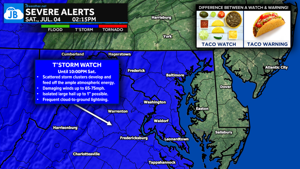
A Severe Thunderstorm Watch has been issued for much of the Mid-Atlantic through 10:00 PM Saturday, covering Washington D.C., much of Maryland, Virginia, eastern West Virginia, and nearby coastal waters.
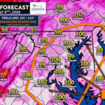
This watch comes during one of the hottest days of the year, as temperatures climb to around 100° and heat index values soar between 105° and 110°. That combination of intense heat, abundant humidity, and an approaching disturbance is expected to fuel numerous thunderstorms this afternoon and evening, some of which could become severe.
The timing couldn’t be more impactful, as many Fourth of July parades, cookouts, and fireworks celebrations are planned across the region. While not everyone will see a storm, those that do could experience rapidly changing and dangerous weather.
What’s Driving Today’s Threat?
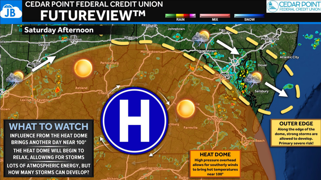
The same heat dome responsible for this week’s dangerous temperatures is beginning to weaken just enough to allow storms to develop.
Think of the atmosphere as a pressure cooker. Several days of extreme sunshine have heated the ground and loaded the atmosphere with tremendous energy. At the same time, a disturbance moving along the northern edge of the heat dome is providing the spark needed to ignite thunderstorms.
Storms are expected to develop first along and east of the Blue Ridge before spreading eastward through the afternoon and evening. With so much heat and moisture available, storms will have no shortage of fuel.
One ingredient forecasters are closely watching is very steep temperature changes with height in the atmosphere. In simple terms, warm air near the ground and much cooler air aloft allow thunderstorms to grow quickly. As rain-cooled air rushes toward the ground, it can produce powerful downburst winds, which is why damaging straight-line winds are the primary concern today.
Main Threats
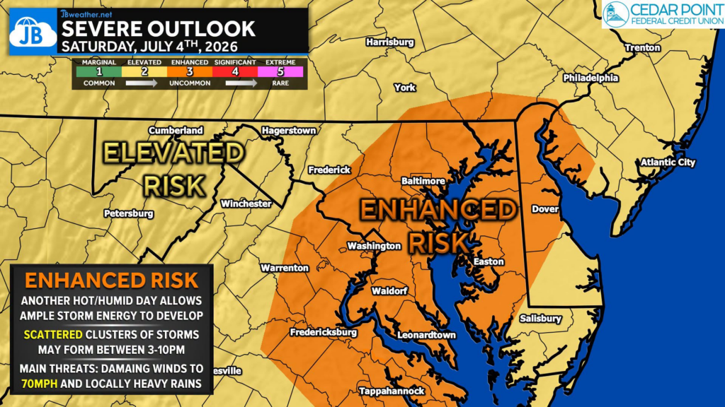
💨 Damaging Winds (Primary Threat): The greatest concern is widespread damaging wind gusts. Wind gusts of 60 to 75 mph are possible. Trees and power lines could be brought down. Scattered power outages are possible. Outdoor tents, canopies, inflatables, and holiday decorations could easily be damaged or blown away.
⚡ Frequent Lightning: Every thunderstorm will produce dangerous cloud-to-ground lightning. If you hear thunder, move indoors immediately.
🧊 Isolated Large Hail: A few of the strongest storms may also produce hail up to 1 inch in diameter, although this is a secondary concern compared to the wind threat.
🌧️ Heavy Downpours: Brief torrential rainfall may reduce visibility and cause localized flooding of poor drainage and low-lying areas.
Timing
2 PM – 4 PM: Storms begin developing near the Blue Ridge and higher terrain.
3 PM – 9 PM: This is the highest-risk window for severe weather. Thunderstorms will become more numerous while moving east across central Maryland, northern Virginia, southern Pennsylvania, the D.C. metro, and eventually toward the Chesapeake Bay and Delmarva.
After 9 PM: Storms gradually weaken, although a few could linger long enough to affect evening fireworks celebrations.
Watch vs. Warning
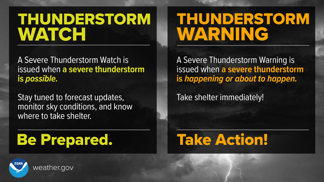
A Severe Thunderstorm Watch means conditions are favorable for severe thunderstorms to develop. A Severe Thunderstorm Warning means a severe thunderstorm is happening or is about to happen, and action should be taken immediately. Remember:
🌮 Taco Watch = The ingredients are on the counter.
🌮 Taco Warning = The taco is ready to eat.
Bottom Line
This is shaping up to be one of the more active weather days we’ve seen in several weeks.
You’ll first have to contend with dangerous heat, but by mid to late afternoon the focus shifts to thunderstorms capable of producing damaging winds.
If you have outdoor Fourth of July plans:
- Stay hydrated during the day.
- Keep a close eye on radar this afternoon.
- Have multiple ways to receive warnings.
- Know where you’ll seek shelter if storms approach.
Remember, a Severe Thunderstorm Watch means conditions are favorable for severe storms to develop. It is not a warning, but it is a signal to stay weather-aware and be prepared to act quickly if warnings are issued.
Key Takeaways
- ⚠️ Severe Thunderstorm Watch in effect until 10 PM across much of the Mid-Atlantic.
- 🌡️ Heat indices of 105–110° will fuel an extremely unstable atmosphere before storms develop.
- ⛈️ Numerous thunderstorms are expected between 3 PM and 9 PM, with the strongest capable of producing 60–75 mph damaging wind gusts, frequent lightning, and isolated hail.
- 🎆 If you’re attending Fourth of July festivities or fireworks, have a backup indoor location and a reliable way to receive weather warnings. Conditions may change quickly late this afternoon and this evening.
Stay with JB Weather for the latest information on impacts here in Southern Maryland and across the Mid-Atlantic. You can always access my forecasts and updates here on the website, on Facebook, on Twitter, on Instagram, and on YouTube. JB Weather is the Mid-Atlantic’s Weather Leader, and I am working around the clock to keep you ahead of any storm!
John Bordash
View More PostsJB Weather forecaster John Bordash is working around the clock to provide Southern Maryland, and neighboring communities, with accurate and reliable weather information.