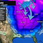
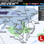
After our cold settles in late this week, we will see a system move east out of the Great Plains. There are several questions regarding this, which is expected 5-6 days out. With that said, this will bring the threat of some winter weather for early next week…
It seems pretty likely that a system will exist. The biggest question I have right now is how far north this system will track. That will be determined by how powerful the cold air to the north is.
If the cold air is not strong enough, the storm will lift northward leading to a wintry mix/rain solution. If the cold air is too strong, it will suppress the storm well to the south. If the cold air can get established but not be overbearing, we would then see wintry weather for the Mid-Atlantic.
It’s too early to say which solution is favored, let alone which will win out. We’re just too far out to say. However, this is certainly something I will be watching. Any weather impacts would be late Sunday (1/5) into your day on Monday (1/6). Still plenty of time to watch.
There will be a lot of clickbait and hype, I’m sure, with this. From my now 11-year background (which is just crazy!) I have learned to wait this out for a few more days as our models will be all over the place. *If* the Mid-Altantic does see snow, this would not likely be a big, blizzard. Stay tuned!
Brought to you by Chesapeake Orthodontics. Dr. Thomas Hao and Dr. Dylan Schneider offer comprehensive orthodontic services for all ages. Schedule your free consultation today. Visit www.SOMDBraces.com today for more information!
1 thought on “Early Next Week: System To Watch”
Comments are closed.


[…] Source link […]