Brought to you by Chesapeake Ice
A developing winter storm is set to bring impacts to much of the Mid-Atlantic on Sunday. As opposed to the track our storm earlier this month took, we are likely to see this storm take a track that favors areas northwest of I-95. Impacts will be likely for most as brutal cold follows the storm.
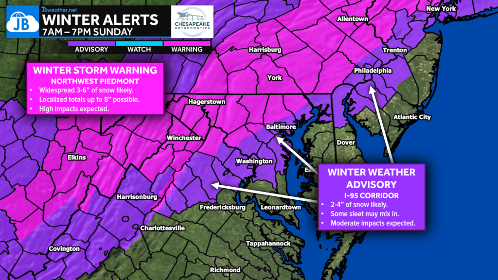
Alerts: The National Weather Service has hoisted Winter Storm Warnings (in pink) for the Piedmont areas northwest of I-95. These zones are where the heaviest snow looks likely to fall between sunrise and sunset on Sunday. Winter Weather Advisories (in purple) have been issued along the I-95 corridor for lesser but still impactful amounts of snow. There are no alerts at this time for central Virginia, southern Maryland, or the Delmarva, as mixing/rain will keep totals lower there.
Timing: Our Cedar Point Federal Credit Union Futureview shows precip overspreading the region after sunrise on Sunday. The precip is likely to start as rain southeast of DC with snow to the northwest. The snow could turn heavy at times northwest of DC. The rain/snow line will drive southeast as cold air moves in. Areas southeast of DC may see the rain end as a period of snow before the system moves out by sunset.
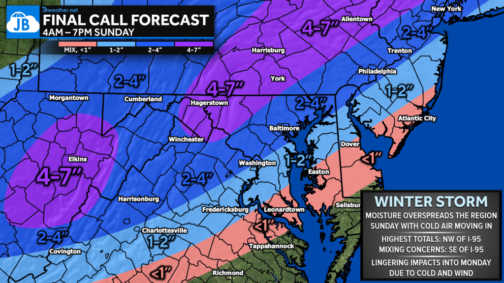
Snow Accumulations: A general 2-4″ of snow looks likely northwest of I-95. This is where the precip will likely be snow for much of the event. 4-7″ looks possible for the higher elevations further inland where heavier snow may fall, and colder temps may allow the snow to pile up faster. Only 1-2″ is expected just southeast of I-95, thanks to a slower transition to snow. Less than an inch is expected for much of southern Maryland, Tidewater, Virginia, and the Delmarva as the rain and mixing will likely hold on longer there.
Boom/Bust: If this system were to shift southeast or northwest, it would certainly shift where the heaviest snows would fall. Additionally, temperatures will play a big role here. If the cold air can drive in quicker, southeastern zones could see up to 1-3″. However, if the temperatures are warmer, even areas along I-95 may struggle to see much.
Storm FAQs
How confident are you in your forecast? My confidence in this forecast is high. This system seems like a textbook overrunning pattern with a system developing along a stalled cold front. The only question is how fast the cold air moves in.
Where will the heaviest snow fall? The highest totals look likely to be focused northwest of I-95 in the Piedmont zones.
When will the precip start? Current guidance shows that the snow may begin late Sunday morning, likely between 6-9am.
When will the heaviest snow fall? Probably during the late morning hours northwest of I-95.
When will the snow end? Snow will likely end around sunset on Sunday, between 4-7pm. It will be during these waining hours of the event that areas in Southern Maryland may switch to snow.
How much snow will I get at my house? Check out the accumulation map. Generally, I’m expecting 2-4″ northwest of I-95 with 4-7″ in the highest elevations. 1-2″ along I-95 with less than an inch for southern Maryland.
Could more or less snow fall than currently forecast? Absolutely. Check out the Boom/Bust scenarios above! Below are my current thoughts of snow accumulations in Southern MD.
50% chance: <1″
30% chance: 1-2″
20% chance: 2-4″
Any chance of a wintry mix of freezing rain or sleet? Periods of sleet and freezing rain will be likely during the midday hours of Sunday as the cold air pushes the rain/snow line southeast.
What impacts can I expect? Generally speaking, I am expecting the highest impacts northwest of I-95 where the highest snow totals will be. However, elevated impacts extend down into southern Maryland as the incoming cold will freeze any wet spots.
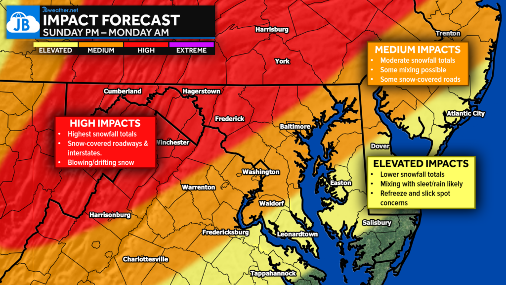
Closing Thoughts: All in all, this looks to be a very typical system for our region. Plan on impacted Sunday from the weather. Areas northwest of I-95 will see several inches of snow with areas southeast of I-95 battling the rain/snow line. One thing is for sure… we will turn mighty cold behind this system!
Stay with JB Weather for the latest information on impacts here in Southern Maryland and across the Mid-Atlantic. You can always access my forecasts and updates here on the website, on Facebook, on Twitter, on Instagram, and on YouTube. JB Weather is the Mid-Atlantic’s Weather Leader, and I am working around the clock to keep you ahead of any storm!
Chesapeake Ice is your local Ice Distributor and Manufacture for Southern Maryland. Please contact us now for your summertime Ice and Canned Artisan Water needs. Please check out our Facebook and website chesapeakeice.net.
