Brought to you by G&H Jewelers, Inc.
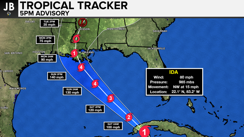
Things have continued to look worse for the Gulf Coast ahead of Ida’s arrival this weekend. The storm has already rapidly strengthened into a Category 1 Hurricane. This strengthening comes well ahead of schedule as the storm makes landfall in Cuba. Ida will reemerge over the open Gulf of Mexico water late tonight. From there, the storm will have about 24-36 hours over the warm Gulf waters. Coupling the warm waters with the very favorable atmospheric pattern that’s in place will allow the storm to continue rapidly intensifying. The National Hurricane Center is now calling for a Major Category 4 Hurricane to make landfall Sunday evening. This will bring an Extreme Threat to Southeastern Louisiana. Evacuation orders have already gone out for parts of the New Orleans, LA metro area.
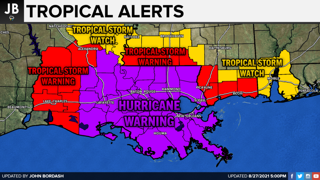
Hurricane WARNINGS are now up for the central Gulf Coast ahead of Ida. This is where some of the worst wind will occur with the storm. Tropical Storm Warnings are up for areas further out from the center, where the winds will still be damaging, just not at hurricane strength. These warnings are also in effect further inland as well.
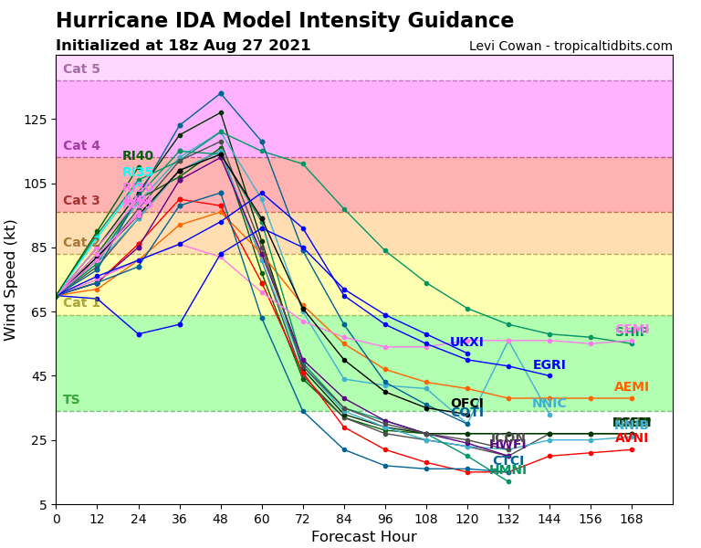
INTENSITY: This is the part of the forecast that is perhaps the most concerning. Many of our forecast models have had to adjust their forecasts UPWARD with the storm’s future intensity. Ida has already begun to rapidly intensify, and there is very little to stop it from continuing to do so once it reaches the Gulf of Mexico. Shown below is a chart showing how each different model (represent by the lines) forecasts the storm’s intensity over time. Many models do now show Ida reaching Category 4 strength before landfall. It is entirely possible that this storm reaches Category 5 strength as well. If Ida makes landfall on the US coastline as a Category 5 storm, it would only be the fifth storm of such strength to do so in recorded history. Hurricane Katrina was only a Category 3 storm when it made landfall near New Orleans in 2005. We will need to watch additional trends with the intensity guidance, as recent trends have really brought the potential strength up.
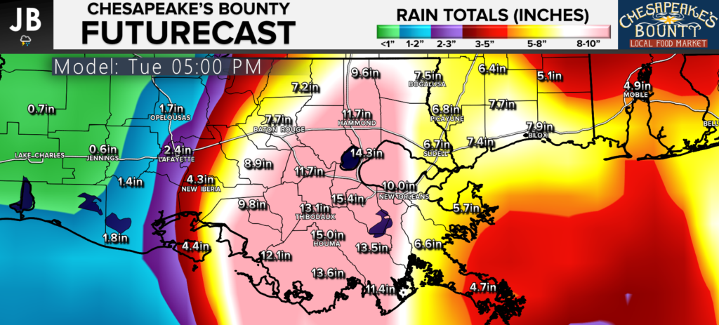
RAINFALL: This could cause major impacts across the central Gulf Coast. Our models are showing the potential for widespread 10-20″+ amounts across this region. The Gulf Coast has already seen one of its wettest summers on record. This additional rainfall alone could cause major issues. This zone of heavy rain could still shift around, so all areas
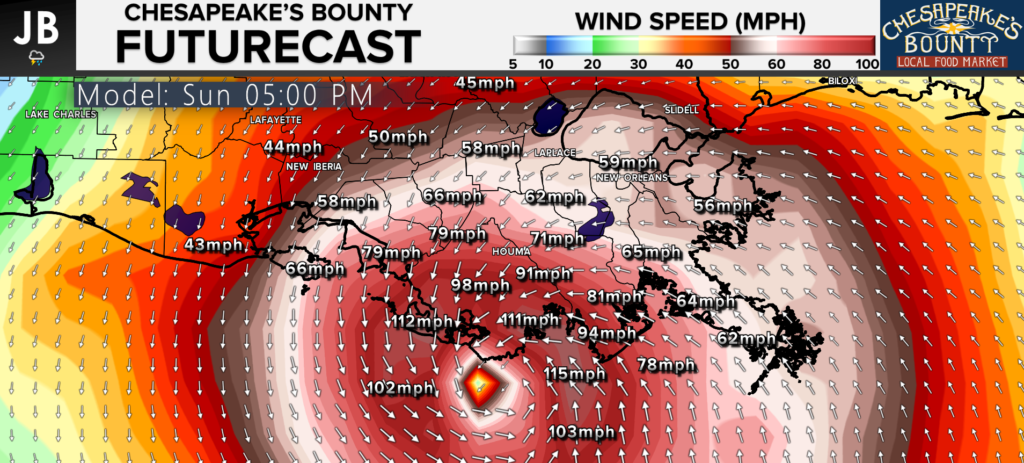
WINDS: As mentioned above, the winds with Ida will be damaging in many areas. The National Hurricane Center is now forecasting for a Category 4 storm, with winds of 140mph and gusts up to 165mph, to make landfall in Southeast Lousiana Sunday evening. While the 120mph+ winds will be confined to the eyewall, hurricane-force winds (74mph+) will extend out quite a way. Tropical-storm-force winds (39mph+) will extend out even further. Our model has a hard time forecasting exact wind speeds, but it does give a general idea of the low range forecast. Even this model shows winds of 115mph+ in the eyewall, which is likely underdone. If we see Ida strengthen to a Category 5 storm, which is possible, winds could exceed 160mph.
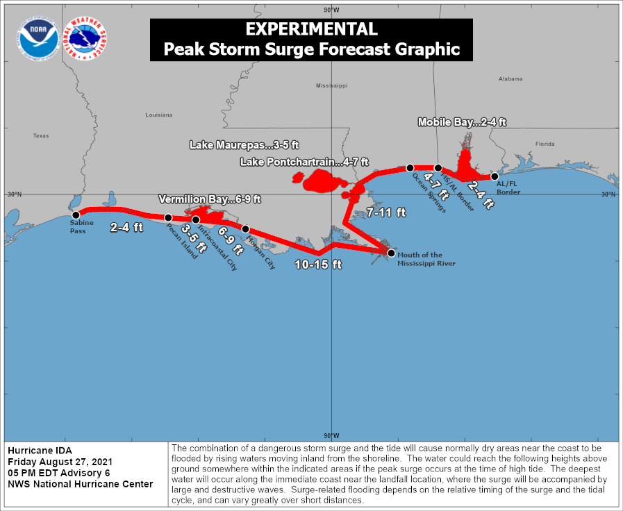
STORM SURGE: All of the onshore wind will also allow for a deadly storm surge to roll on land. The National Hurricane Center is now forecasting a storm surge of 10-15 feet to affect southern parts of Louisiana. There could be as much as 7-11 feet of surge push up along the Mississippi, and into the New Orleans, LA area. All of this could washout single-story buildings for quite a ways inland. This will cause significant damage.
Hurricane Ida is setting up to be a major threat to the Gulf Coast. This could be the most devasting storm we have seen since Hurricane Katrina hit this exact same region 15 years ago on Sunday. All interests in this region need to be heeding all warnings. Devasting impacts are LIKELY for many regions. Those that stay behind to ride out this storm could be making a life-or-death decision. Landfall looks likely to occur Sunday evening and could happen as the storm enters into Category 4 or 5 strength. Those in this region should prepare now and head inland ahead of the storm.
It will be important to stay with JB Weather for the latest information on Ida and the potential impacts along across the Gulf Coast. You can always access my forecasts and updates here on the website, on Facebook, on Twitter, and on YouTube. JB Weather is Southern Maryland’s Weather Leader, and I am working around the clock to keep you ahead of the storm!
-JB
Shop G&H Jewelers Today for Loose Diamonds, Fine Diamond & Colored Gemstone Jewelry, On-site Custom Jewelry Design (CAD) & Manufacturing, Jewelry Repair and GIA Graduate Gemologist Appraisal Services. Third Generation Family Owned & Operated Since 1965.
John Bordash
View More PostsJB Weather forecaster John Bordash is working around the clock to provide Southern Maryland, and neighboring communities, with accurate and reliable weather information.