Brought to you by Cedar Point Federal Credit Union
Our area has now been upgraded to a Level 3 “Enhanced Risk” for severe thunderstorms on Saturday. This means confidence is increasing that scattered severe storms capable of producing damaging winds will develop, with large hail and a few isolated tornadoes also possible.
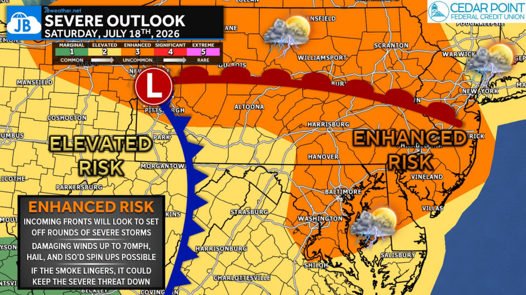
A powerful upper-level storm system and an unseasonably strong cold front will move into the region tomorrow. As the front approaches, hot, humid air will surge northward, creating an increasingly unstable atmosphere. At the same time, strong winds several thousand feet above the ground (35-45 knots of wind shear) will help organize thunderstorms into stronger, longer-lived storms capable of producing widespread severe weather.
💨 The primary threat will be damaging straight-line winds, with gusts that could exceed 60-70 mph, capable of downing trees and power lines and causing scattered power outages. Large hail is also possible, and while the tornado threat appears lower, an isolated tornado cannot be ruled out, especially if storms interact with the returning warm front or leftover boundaries from earlier storms.
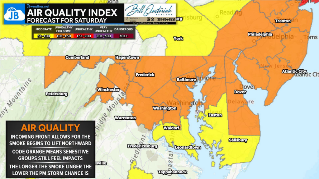
🤔 One big question remains… the wildfire smoke.
The thick Canadian wildfire smoke we’ve dealt with over the past several days has significantly reduced sunshine and surface heating. Less heating generally means less instability, which can keep storms from reaching their full potential. Because of that, I’m a bit skeptical that tomorrow’s severe threat will become as widespread as currently advertised if the smoke lingers longer than expected.
However, forecast models and the National Weather Service expect winds to gradually shift tomorrow, allowing much of the smoke to thin and move out during the afternoon. If that happens and we see several hours of sunshine, the atmosphere could quickly become much more unstable, allowing storms to intensify rapidly. In other words, the amount of smoke that remains tomorrow afternoon may ultimately determine just how significant this event becomes.
⏰ Timing:
- Morning: A few showers or storms are possible, mainly north.
- Afternoon: Scattered severe thunderstorms begin developing.
- Evening: Another, potentially stronger line of storms may sweep through with damaging winds and torrential rainfall before moving south overnight.
I’ll be monitoring trends closely throughout the day tomorrow, particularly how quickly the smoke erodes, as that will likely be one of the biggest factors in determining how this forecast ultimately plays out. Stay with JB Weather for the latest information on impacts here in Southern Maryland and across the Mid-Atlantic. You can always access my forecasts and updates here on the website, on Facebook, on Twitter, on Instagram, and on YouTube. JB Weather is the Mid-Atlantic’s Weather Leader, and I am working around the clock to keep you ahead of any storm!

Cedar Point has been providing trusted banking, lending and personal finance solutions to the Southern Maryland Community since 1945. Visit the credit union at any of its 6 locations in St. Mary’s, Charles and Calvert counties or online at www.cpfcu.com.

John Bordash
View More PostsJB Weather forecaster John Bordash is working around the clock to provide Southern Maryland, and neighboring communities, with accurate and reliable weather information.