Brought to you by Cedar Point Federal Credit Union
Winter has felt a bit off and on this season thanks to a lack of sustainable cold air, but an abundance of moisture. Another system is set to bring a healthy bout of moisture to the Mid-Atlantic tonight. However, enough cold air may settle in to help northern areas switch over to a period of snow.
Our Cedar Point Federal Credit Union Futurecast shows rain overspreading the region this evening. Some spots south of the Mason-Dixon Line could see up to an inch of rain! Cold air will look to sneak southward by the early morning hours of Tuesday. Futurecast shows this leading to a change-over to a few hours of heavy, wet snow northwest of I-95 by sunrise on Tuesday.
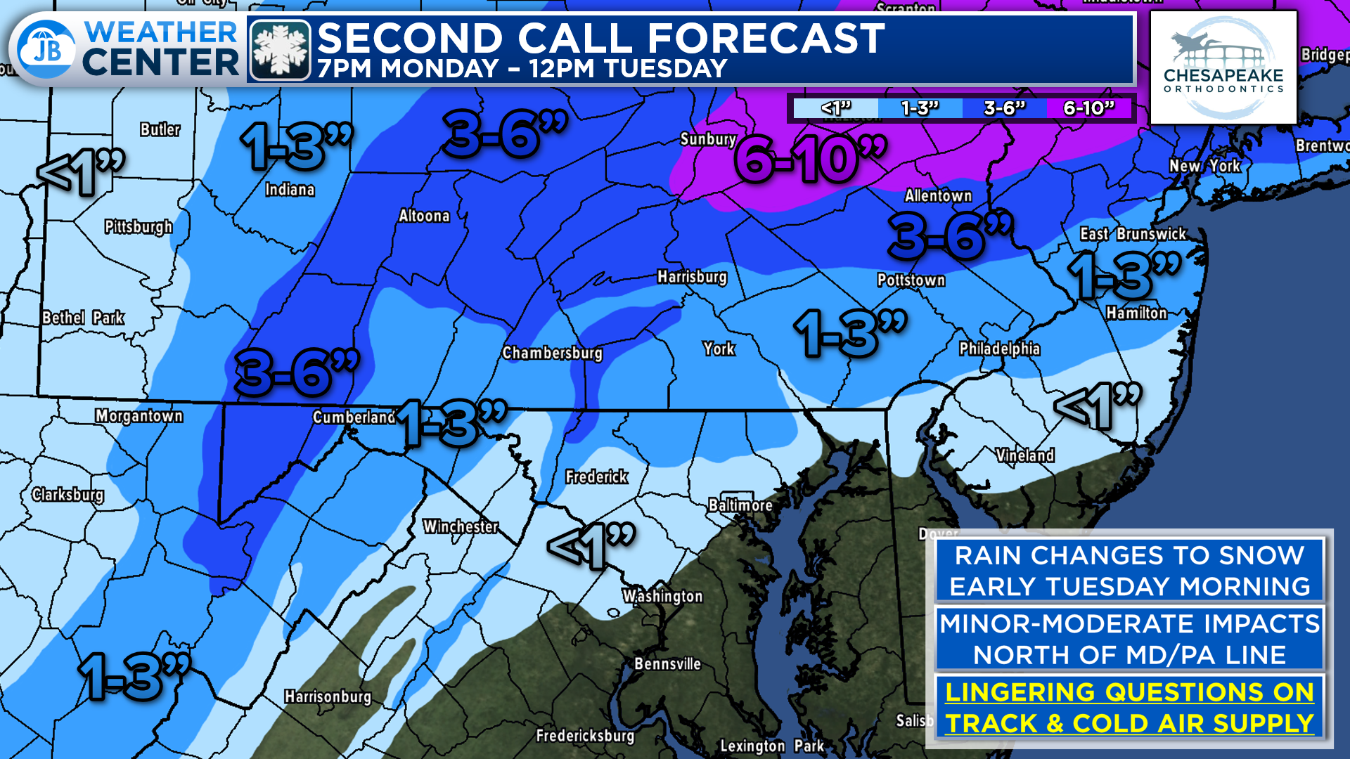
Right now, minor to moderate accumulations look possible for Piedmont areas northwest of I-95. More snow will be found in the northern parts of PA, NJ, and into NY. There are still plenty of questions about the exact track of this system as it moves across the southern Mid-Atlantic and the supply of cold air. A more southerly track and/or more cold air (which some models do show) would mean that these numbers may need to be increased.
It is important to note that accumulations in PA, especially on roadways, may be hard to come by initially, thanks to the recent string of warmth. The snow will need to come down fast enough to overcome this and create its own cold air. Again, we do have a few models, like our own Futurecast model, that show this happening. This would potentially create impacts for the Tuesday morning commute.

While this will be a rainmaker for our followers southeast of I-95, areas along and north of the Mason-Dixon Line are likely to contend with winter weather tomorrow morning. Minor to moderate impacts look likely thanks to a couple of hours of snow. Impacts on the Tuesday morning commute are certainly possible north of Baltimore! This is a low-confidence forecast thanks to the outstanding questions on track and cold air. But this is one to watch! Updates to come this evening.
Stay with JB Weather for the latest information on impacts across the Mid-Atlantic. You can always access my forecasts and updates here on the website, on Facebook, on Twitter, and on YouTube. JB Weather is Southern Maryland’s Weather Leader, and I am working around the clock to keep you ahead of any storm!
-JB
Cedar Point has been providing trusted banking, lending and personal finance solutions to the Southern Maryland Community since 1945. Visit the credit union at any of its 6 locations in St. Mary’s, Charles and Calvert counties or online at www.cpfcu.com.
John Bordash
View More PostsJB Weather forecaster John Bordash is working around the clock to provide Southern Maryland, and neighboring communities, with accurate and reliable weather information.


1 thought on “Rain Changes to Snow for Northern Areas Tuesday Morning”
Comments are closed.
[…] Story continues […]