Brought to you by Cedar Point Federal Credit Union
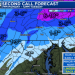
It has felt like Spring the last several days! However, we will see Winter try to make a bit of a comeback this coming week. A quick-moving system will move through the Mid-Atlantic Monday night as cold air tries to move in. This will likely lead to some #snow for northern areas.
We’re still a bit too far out to forecast specific amounts or impacts. This is thanks to questions about the exact track of the system and the amount of cold air. Both are important. However, it does look like interior areas of the Northeast will be favored with this event.
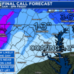
The rain/snow line will likely dance around the Mason-Dixon line with this event. North of there, a couple to a few inches of snow could be possible overnight Monday into Tuesday morning. A cold rain is likely south of there.
This is likely not our last chance of winter weather for the season. Widespread winter weather chances likely increase for the last couple weeks of February.
Stay tuned for additional updates on this system and the large-scale pattern changes to close out Winter!
Cedar Point has been providing trusted banking, lending and personal finance solutions to the Southern Maryland Community since 1945. Visit the credit union at any of its 6 locations in St. Mary’s, Charles and Calvert counties or online at www.cpfcu.com.
John Bordash
View More PostsJB Weather forecaster John Bordash is working around the clock to provide Southern Maryland, and neighboring communities, with accurate and reliable weather information.