Brought to you by G&H Jewelers, Inc.
It looks like our first snow event of the season may be on track to arrive on Wednesday. The big questions that have been getting asked are, “how much snow,” and “how big of an impact?” Highs today reached the upper 60s and lower 70s and ground temperatures are relatively warm after the last few days. However, temperatures will be on their way down behind tonight’s cold front. This will set the stage for wintry precipitation as a system passes to our south early Wednesday. If you are looking for a quick summary of the forecast, take a look at the Storm FAQs, towards the bottom of the page.
Cold air will quickly filter into our region on Tuesday, behind tonight’s cold front. As a result, temperatures are likely to only reach the lower to middle 40s for highs. Late Tuesday night, a system will begin developing across the southern US. This system will push off the Carolina coast, and out to sea, on Wednesday. This system likely will not be a strong one, leading to limited moisture. However, there should be enough moisture that works with the cold air Wednesday morning to lead to a rain/snow mix.
Timing It Out
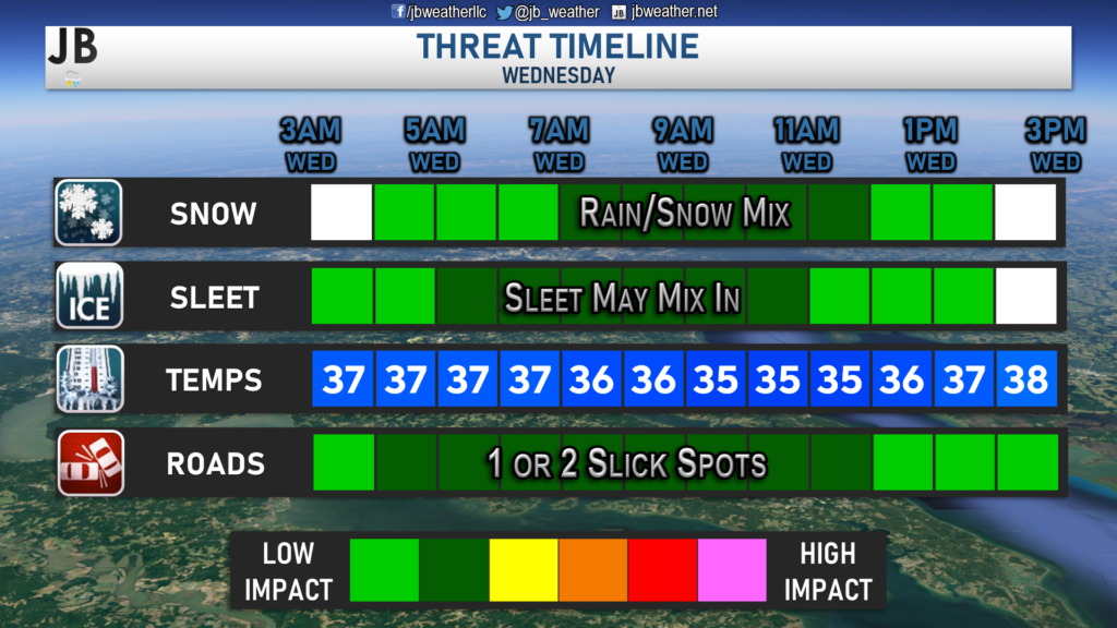
Precip will look to begin moving into the region during the pre-dawn hours on Wednesday. Most areas should be seeing some form of precipitation fall by 4/5am. Temperatures are likely to be above freezing at the onset of precipitation in Southern MD, which should lead to more of a rain/snow mix, with some sleet at times. Temperatures will look to be a few degrees cooler to the northwest of DC, allowing for mostly snow to fall there. Temperatures will look to cool though as the precipitation falls. This dynamic cooling should help to switch areas south and east of DC to more of a snow/sleet mix, or potentially just snow, by mid-morning. The precip will look to wrap up out of here by lunchtime.
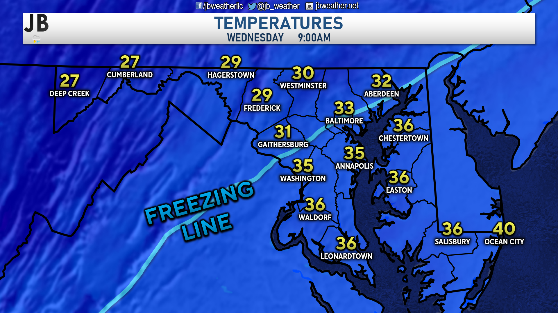
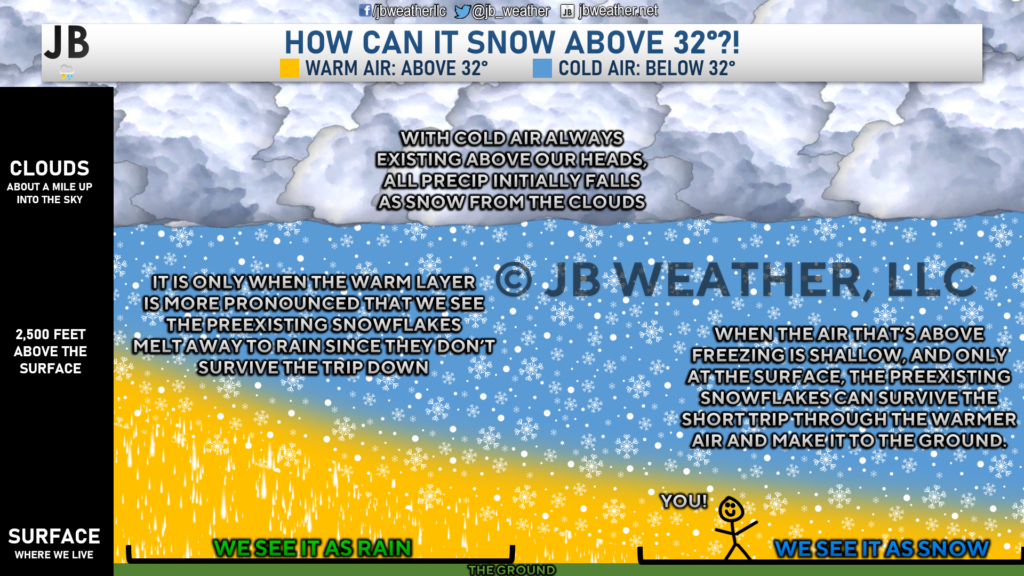
As noted, temperatures will be marginal Wednesday morning. While most areas should be in the 30s for the duration of the storm, locations south and east of DC look to remain above freezing. Above, you can see how temperatures look to be set up during the “height” of the event. The freezing line would likely be set up just NW of I-95. However, we do know that we can get snow above 32°.
The Forecast
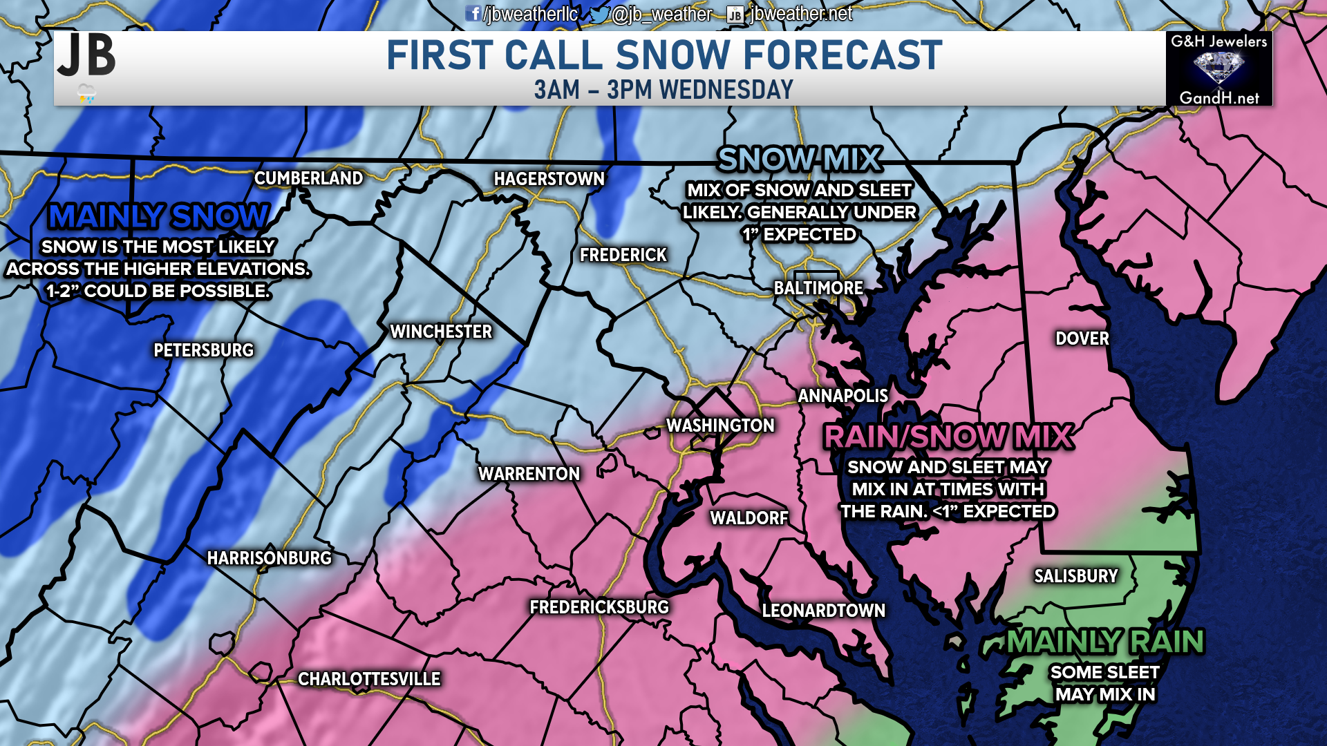
This event does not look to be some sort of big snowstorm. This is a weak system with limited moisture, which will keep any snow amounts down. As is the case with early-season winter weather events, areas northwest of I-95 will be the ones that are favored to see more snow. That is where we are likely to see cooler temperatures throughout the event and they could see mainly snow. Most of these areas should stay under an inch, but the higher elevations in the mountains could pick up closer to 1-2″. For my friends and followers in south-central PA, I think many of us stay under an inch.
Areas along and to the southeast of DC are likely to see a rain/snow mix, and this does include all of Southern MD. This will be thanks to the initially warmer temperatures. I am not expecting very much accumulation in this region either, likely only a coating in some spots. This zone may see some sleet fall though. This could lead to a thin layer of ice pellets on grassy surfaces. However, I am not expecting a large ice impact in this region. The further south and east you head, you are likely to see more rain and less snow. An area like Waldorf could see a couple of hours of light snow while an area like Ridge may struggle to see more than an hour of light snow. Areas on the lower Eastern Shore are likely to see mainly rain, with some sleet at the end.
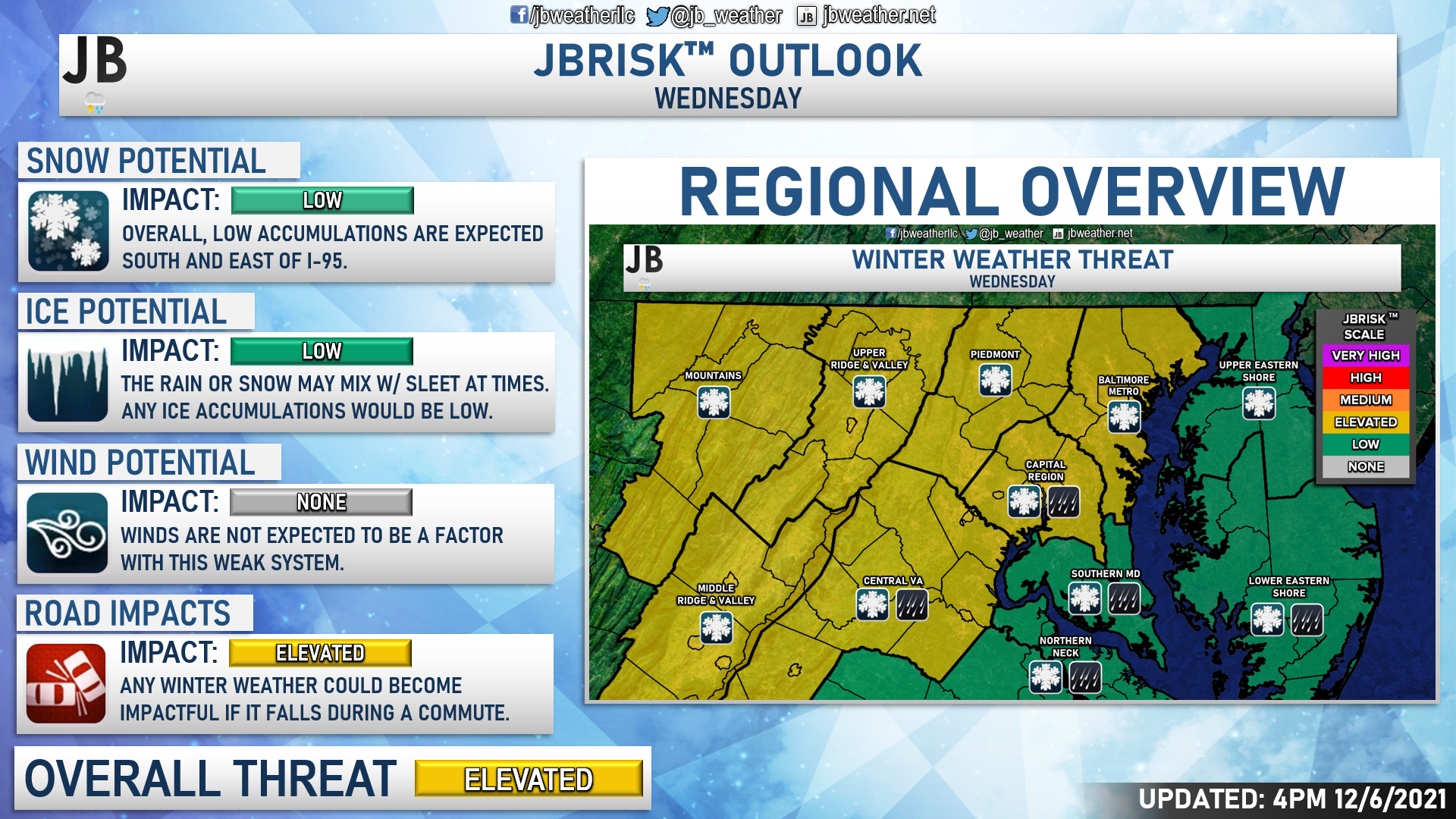
Regionally, the more elevated impacts are likely to be found north and west of our region. Areas NW of I-95 could see a light coating to an inch of snow, with some of that accumulating on grassy areas. I am not expecting high travel impacts for any region, but there could be slowed traffic once you head NW of I-95. This could impact 1 or 2 school districts in parts of Western MD or West Virginia. At most, there may be some delays in that region. Again, we’re not talking about big snow or ice totals, but with the morning commute in mind, it could lead to some slowed travel in that area.
Locally, we are likely only talking about low impacts. Warmer temperatures will help to keep our region as more of a rain/snow mix as opposed to a pure snow event. The warmer air will also help to limit any road impacts as well. I would not expect much in the way of travel delays or school delays SE of I-95
Storm FAQs
How confident are you in your forecast? I confident that we’ll have a sloppy mix of precipitation on Wednesday. The big questions are will it snow hard enough and will temperatures fall quickly for snow to accumulate. I believe the answers to both of those questions will likely be no, but there is some uncertainty though.
How much snow will I get at my house? Check out the accumulation map. Generally, I’m expecting less than an inch of snow north of DC and potentially only a few flakes to a coating SE of I-95 where temperatures will be marginal for snow.
Could the storm bring more snow than expected? Yes. In order for this to happen, we will need heavy precipitation to develop. That will help to cool the air and high snowfall rates might overcome the effect of the warm ground. I would say that there’s a 1 in 5 chance of 1″+ in a few spots. This does not look like a big event at all, so the high-end ceiling for this event is rather low.
Could it fizzle out and leave us wet? Yes. A significant impediment for snow accumulation is the relatively warm air (temperatures above freezing) that will be in place when the precipitation first arrives. It will take some time for the precipitation to cool the air and for precipitation to change from rain to a rain/snow mix or even to just snow. It is likely that some spots may see no snow at all because of this.
Could we see nothing at all? Yes! It is also very possible that dry air overtakes the system, and leads to very little falling. This has happened in the past when weak systems try to overspread moisture across the region. I would place the chance of this happening at 1 in 4.
Will we see any of the dreaded wintry mix? There may be a period of a rain/snow mix and even some sleet as precipitation transitions to snow, but no ice will accumulate given warm ground temperatures.
When will this storm start? Early Wednesday morning between 3 and 6 a.m. in most spots.
When will the heaviest fall? Most likely during the mid-afternoon hours, but we’re likely not talking about heavy snow.
Will the snow stick? It’s not likely in Southern MD. Colder locations to the north and west could see the snow sticking on the grass and on some backroads, thanks to cooler temperatures. In the milder locations south and east of I-95, sticking will likely not happen. If it does happen, it would only be on cooler surfaces such as the top of your car and on your deck.
What will conditions be like after the storm? We will be left with clouds for much of Wednesday, after the system moves out. Temperatures will only max out in the upper 30s during the afternoon. Temperatures go back down below freezing after sunset, which could cause 1 or 2 slick spots to form. However, a mass refreeze is not likely.
Summary
All in all, this does not look to be a big event on Wednesday. We have a weak system sliding to our south that will be moisture-starved. Temperatures will be cool, but will still be marginal for snow. Areas north and west of I-95 are the areas that are the most likely to see snow out of this set up. Along I-95 and to the south and east, we are likely only talking about a rain/snow mix at most. Accumulation and impacts are not likely across Southern MD for Wednesday. Of course, there is a chance that this system trends colder and snowier, which would lead to more elevated impacts. However, I would not bank on that right now. As things stand currently, this system may just serve as the first opportunity for some locations to see their first meaningful flakes.
Stay with JB Weather for the latest information on impacts here in Southern Maryland. You can always access my forecasts and updates here on the website, on Facebook, on Twitter, and on YouTube. JB Weather is Southern Maryland’s Weather Leader, and I am working around the clock to keep you ahead of any storm!
-JB
Shop G&H Jewelers Today for Loose Diamonds, Fine Diamond & Colored Gemstone Jewelry, On-site Custom Jewelry Design (CAD) & Manufacturing, Jewelry Repair and GIA Graduate Gemologist Appraisal Services. Third Generation Family Owned & Operated Since 1965.
John Bordash
View More PostsJB Weather forecaster John Bordash is working around the clock to provide Southern Maryland, and neighboring communities, with accurate and reliable weather information.
1 thought on “Rain/Snow Mix Possible on Wednesday”
Comments are closed.
[…] [ December 6, 2021 ] Rain/Snow Mix Possible on Wednesday Uncategorized […]