The severe weather threat across our region remains conditional and a bit uncertain. Areas south of DC across Southern Maryland, the Northern Neck, and portions of the lower Delmarva will need to keep an eye on the sky later today. This is where a Level 2 “Elevated Risk” of severe weather has been hoisted.
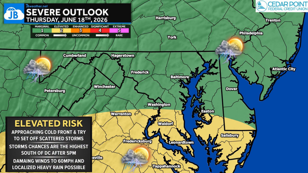
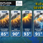
This morning’s showers north and west of DC and cloud cover have already reduced the severe threat. However, if enough sunshine develops this afternoon, the atmosphere could recover quickly ahead of an approaching cold front. Temperatures rising into the lower 90s combined with increasing humidity may be enough to fuel scattered strong to severe thunderstorms.
⏰ The timing for any storms across Southern Maryland & Northern Neck would be 5 PM – 10 PM. Storm coverage is expected to remain scattered, meaning many locations may stay dry while others experience a quick burst of severe weather.
⚠️ The primary threat with any storms includes damaging wind gusts up to 60 mph. Localized heavy downpours, frequent lightning, and isolated tree damage and scattered power outages are also possible.
📍 The greatest severe weather risk currently appears focused across the southern half of the region, where better afternoon heating can occur. Areas that remain cloudy longer may see a lower storm threat, while locations that break into sunshine could see storms become much stronger.
I’ll continue to monitor trends through the afternoon and provide updates if storms begin to organize. Stay with JB Weather for the latest information on impacts here in Southern Maryland and across the Mid-Atlantic. You can always access my forecasts and updates here on the website, on Facebook, on Twitter, on Instagram, and on YouTube. JB Weather is the Mid-Atlantic’s Weather Leader, and I am working around the clock to keep you ahead of any storm!
John Bordash
View More PostsJB Weather forecaster John Bordash is working around the clock to provide Southern Maryland, and neighboring communities, with accurate and reliable weather information.