Brought to you by Calvert Title Company
Hurricane Ida emerged into the Gulf of Mexico late last night and has begun its process of rapid intensification. Ida has already achieved Category 2 Hurricane status as of the 5PM advisory, with winds of 105mph. Additional strengthening to a Category 4 Major Hurricane is likely before the storm rolls onshore tomorrow afternoon. Catastrophic impacts are likely around the point of landfall. High winds and heavy rain will help to spread high to extreme impacts well inland as well. Hurricane Ida will likely be the biggest weather event to strike the mainland US since Hurricane Katrina.
The 5PM Advisory takes the track of Ida northwest over the next day. The storm is likely to come onshore within the next 24 hours over southeast Louisana. The storm’s track today has been to the northeast of the original forecast. With that in mind, the National Hurricane Center has shifted the forecast track of Ida to the east, closer to New Orleans. This eastward shift is bad news for New Orleans, as this puts the flood-prone city closer to the track and area of catastrophic impacts.

WINDS: Ida is likely to roll onshore with winds of at least 110mph– potentially up to 130-140mph. The worst of those winds should be confined to the initial landfall point, and areas just inland. The storm will gradually lose strength as it moves inland, sparing that region from those extreme winds. Hurricane-force gusts of at least 74mph are likely across much of southern Lousiana, including Baton Rouge, Lafayette, and New Orleans. Tropical Storm force gusts of at least 39mph will be likely well inland, getting into Mississippi and northern Lousiana, as the storm tracks northward. Winds of this caliber will cause widespread destruction, and leave hundreds of thousands without power for weeks.

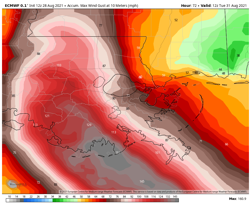
Shown below is the latest European Model depiction of potential wind gusts. This run showed a widespread area potentially getting in on 100mph+ gusts, with an even larger area seeing 70-100mph gusts. Additionally, we can see that the model brings a maximum of 150-160mph winds gusts onshore at the direct landfall point, shown in gray. Any shifts west or east, even by 10-20 miles, will shift this corridor of locally higher winds. This is why an eastward shift towards New Orleans, LA can be viewed as horrible news.
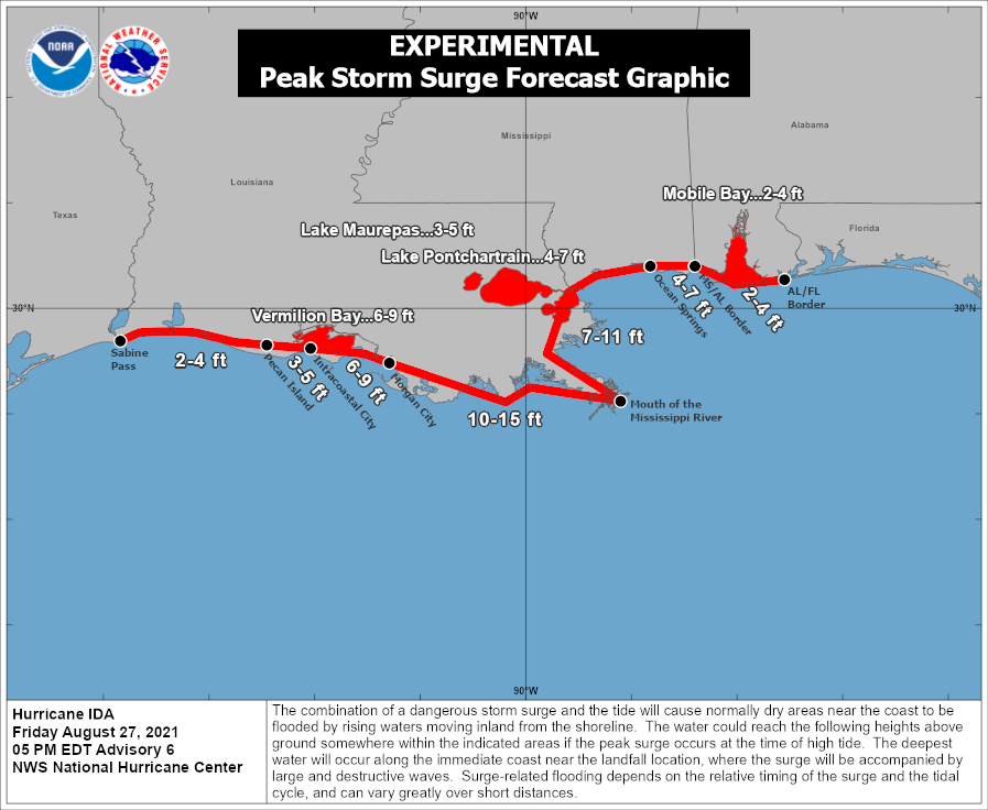
STORM SURGE: The strong onshore winds will also send a 7-15 foot storm surge into much of southeast Lousiana. The National Hurricane Center is forecasting these extreme surge totals along, and just east, of the primary track. This will likely send one of the bigger storm surge threats that New Orleans, LA has seen since Katrina in 2005. All eyes will be on the infamous levee system to see if it can keep up with this wave action. Keep in mind that the surge total shown below would be additional water rise on top of the land and on top of any high tides.
RAIN: This will be another big storm with Hurricane Ida. Tropical moisture will spread northward, bringing flooding rains well inland. As much as 6-12″+ of rain may fall with the storm as moves onshore. The central Gulf Coast has already seen one of its wettest summers in recent memory. This added rainfall will not be good for the region. Like with the wind, any shifts west or east will also shift the axis of the heaviest rain totals.
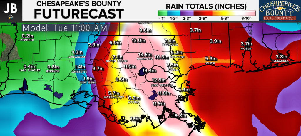
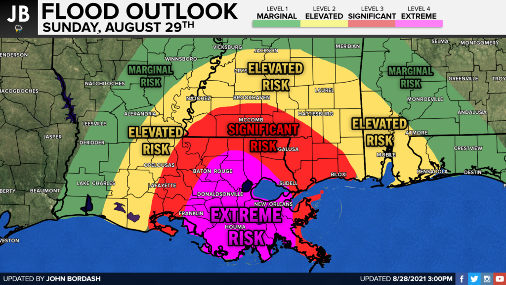
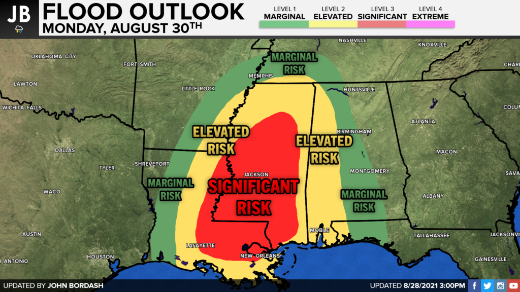
These rain totals will bring an additional flooding threat that is separate from the storm surge. Rainfall-based flooding will pose a great risk for the areas that do get in on the 6-12″+ amounts. Shown below are slides that depict the flooding threat over the next two days. The National Weather Service has already placed much of Lousiana under a rare EXTREME RISK of flash flooding for tomorrow ahead of the storm. The heavy rain threat will continue inland as well, so the NWS has placed much of Mississippi under a SIGNIFICANT RISK for flooding.
Hurricane Ida is setting up to be a major threat to the Gulf Coast. This could be the most devasting storm we have seen since Hurricane Katrina hit this exact same region 16 years ago on Sunday.
It will be important to stay with JB Weather for the latest information on Ida and the potential impacts along across the Gulf Coast. You can always access my forecasts and updates here on the website, on Facebook, on Twitter, and on YouTube. JB Weather is Southern Maryland’s Weather Leader, and I am working around the clock to keep you ahead of the storm!
-JB

Calvert Title Company is guiding you HOME one closing at a time!
