BrougBrought to you by Berkshire Hathaway HomeServices McNeils Group Properties
The highs this weekend are forecast to be in the 60s, but a cold front will be looking to move through the region late Sunday. That sets the stage for the possibility of snow late Sunday night and Monday morning, courtesy of a low-pressure center that will develop and move to our south. This doesn’t look like a big storm for the immediate area, but even the slightest shift in the storm track could mean the difference between no snow and a couple of inches. If you are looking for a quick summary of the forecast, take a look at the Storm FAQs, towards the bottom of the page.
The Set-Up
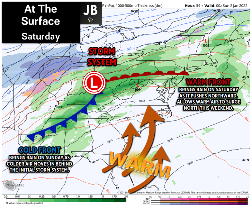
[First image in the slideshow above] A storm system is lifting to our north and west this weekend. An attached warm front moved through the region this morning, which is what helped induce rain across the region this morning, and help warm air surge northward tonight. On Sunday, we will see the lagging cold front move through, which will bring another round of rain and help usher in cold air.
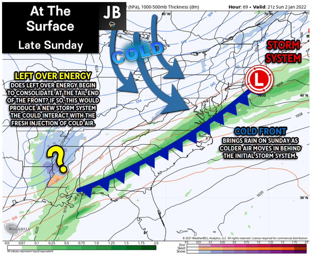
[Second image in the slideshow above] As the cold front moves through Sunday night, we may see some leftover atmospheric energy bundle and consolidate at the tail end of the cold front, in the South. There are a lot of questions on whether this will happen or not. This evening, we have computer models that are in both camps showing this happening and showing this not happening. For Southern MD to see snow on Monday, we would need to see this happen. This would allow for the energy to develop into its own storm system, which could then interact with the cold air.
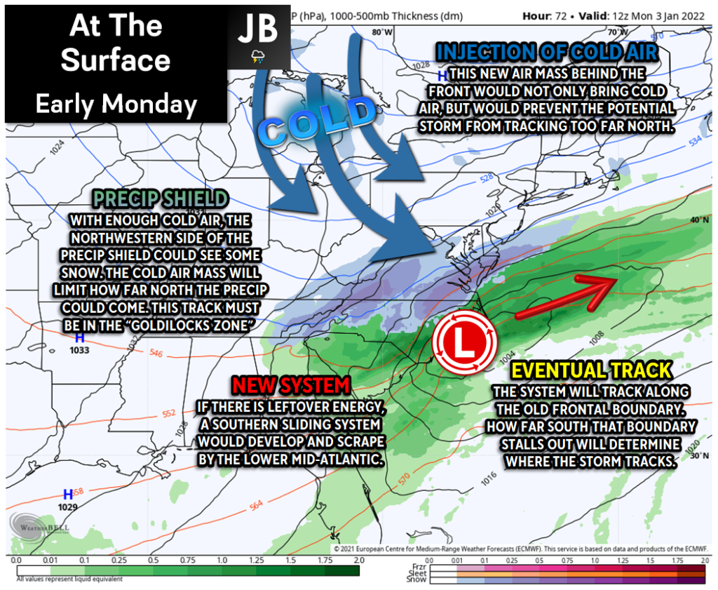
[Third image in the slideshow above] If the energy can consolidate and form a new system, it will track along the cold front; which will stall out just off the coastline. How far south that boundary stalls out would determine where the storm would track. This is where the forecast gets complicated. The fresh injection of cold air will limit how far north this system could come. This likely would prevent any track inland, which would provide us with all rain. However, we would need it to track far enough north, let’s say off of Cape Hatteras and just south of VA Beach, to bring precip into our region. A track in this “Goldilocks zone” would allow enough moisture to be present, and interact with the cold air, to allow for some snow to fall Monday morning.
The Forecast
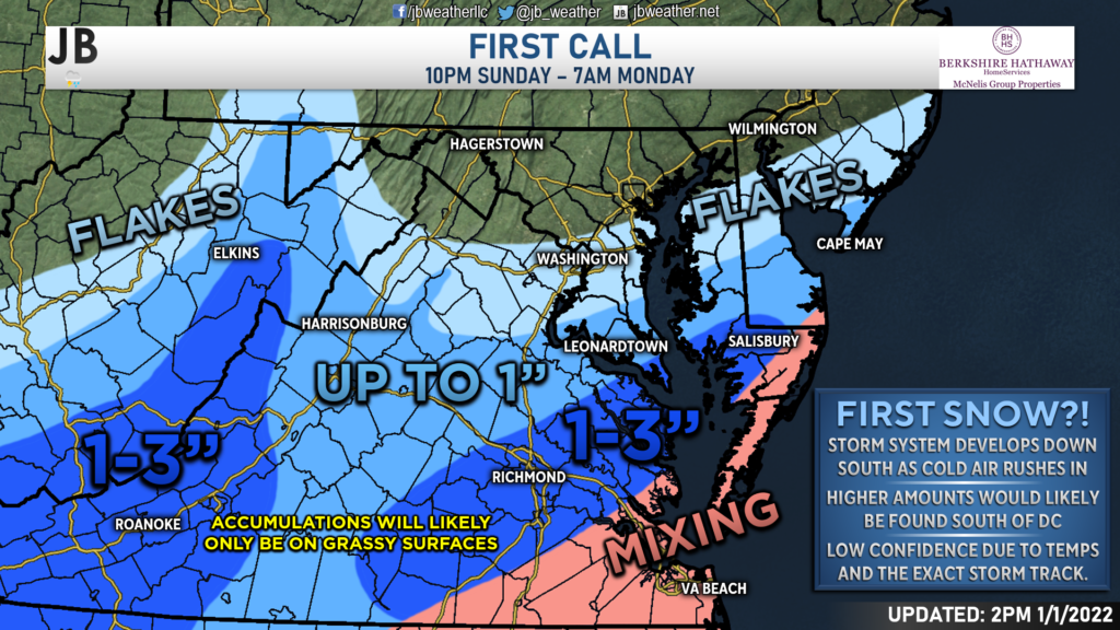
Right now, it appears that a storm will indeed form along the tail end of our cold front and track to the northeast Sunday night. The big questions that remain are how cold we will get behind the front and far north will the storm be allowed to come. Right now, I would favor a more southern solution, where much of our local region sits just on the edge of the precipitation. Areas just to our south, across Tidewater Virginia, could see the highest totals, thanks to heavier precip rates. Areas along the immediate Atlantic coastline will likely have mixing issues, with areas north of DC struggling to see much at all. Any accumulation is likely to be just on the grassy and colder surfaces.
It is very possible that we see the track of this system trend to the northwest. If that happens, then the zone of higher snow totals would need also to get moved further northwest, potentially into Southern MD.
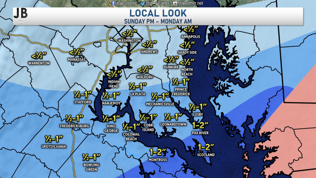
Shown below is a local look at my First Call forecast.
Potential Impacts
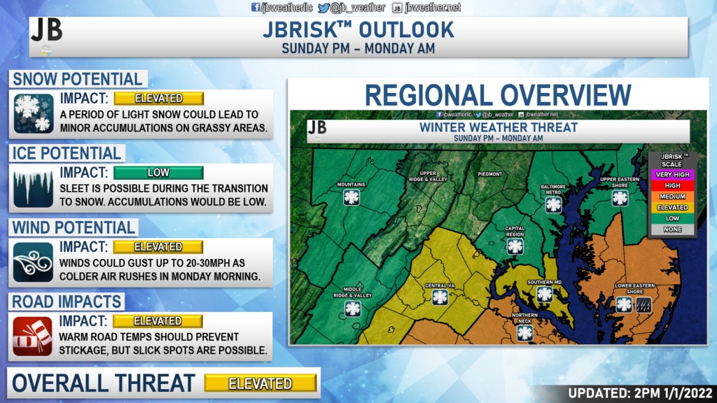
When we take a look at the bigger picture, our region will look to be in an “in-between zone” between low impacts and more moderate impacts. For right now, I will say that Southern MD is on tap for Elevated impacts, largely coming from the light snow and some gusty winds as colder air moves into the region. We could see some roadway impacts, but I am not expecting much stickage, thanks to the warmer roadway temperatures. However, it is possible that some slick spots could form on back roads that are less traveled. Higher impacts will be felt to the southeast, where the higher totals are likely to be. Areas NW of DC are likely to see almost no impacts from this. It is too early to say how this could affect schools and businesses Monday morning. Those details should come into better focus on Sunday.
Storm FAQs
How confident are you in your forecast? My confidence with this forecast sits below average. There are some big questions with how far north the heaviest precip gets, and how cold we are Monday morning. Small shifts with either the track or the temperature profiles on Monday will lead to big differences.
Where will the heaviest snow fall?
The highest snow totals will be south of the DC metro region, closest to the area of the low pressure. Some spots near Richmond may pick up a couple of inches, with Southern MD likely being on the edge of meaningful snowfall and just conversational flakes.
When will the snow start?
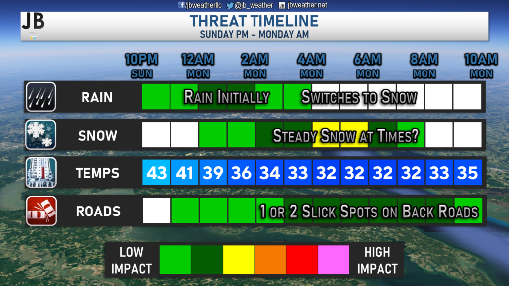
Current guidance shows that the snow may begin very early Monday morning, likely just after midnight. However, rain may begin falling around 10pm Sunday night before we switch over to snow.
When will the heaviest snow fall?
Likely right around sunrise on Monday. While I am not forecasting “heavy” snow per say, I would say that we could see some bands of more steady to moderate snow fall during this time, especially in southern St. Mary’s County.
When will the snow end?
The snow should be winding down between around 7-10 a.m. and clearing out by lunchtime.
How much snow will I get at my house? Check out the accumulation map. Generally, I’m expecting less than an inch of snow across much of the region, but southernmost zones could see an inch or two from this system.
Could more or less snow fall than currently forecast?
Absolutely. In order for more snow to happen, we would need the storm to track further northwest, which would allow heavy precipitation to develop over Southern MD. On the other hand, if the storm takes a slight jog to the south, or if the air is not as cold, many areas will struggle to see much. In light of these plausible scenarios, here’s my assessment of snowfall probabilities:
25% chance: Nothing
50% chance: Coating to an inch
20% chance: 1-3″
5% chance: 3-6″+
As you can see, we have near equal chances of seeing nothing or of seeing 1-3″ of snow in our area. There is an outside chance that we see more than 3″, but I think that chance is very low.
Will the snow stick? For areas that do indeed see snow, it is possible that we see snow accumulation on grassy areas, and on colder surfaces. While it can snow a day after getting into the 60s (it has happened many times before), it is hard to get that snow to stick to the warm blacktop on roadways. Back roads and less traveled streets could develop some slick spots, but I do not expect snow-covered roadways.
Any chance of a wintry mix of freezing rain or sleet?
The chances of that are very low with this storm. While we will be relying on incoming cold air to switch our area over to snow, I do not forsee a prolonged period of ice from this. The only way that this will become an issue is if the storm tracks so far northwest, that we get into the warm sector of the storm. That would require a near 100-150 mile shift northwest. While it is possible, it is unlikely with the way that things stand now.
In Summary…
All in all, this does not look to be an overly big event on Monday, but our region may finally see it’s first snow. We have a weak system sliding to our south as cold air filters into the region. Areas south of DC are the areas that are the most likely to see snow out of this setup. Accumulation and impacts are possible across Southern MD Monday morning. Right now, accumulation looks minor with only a few impacts. However, any shifts to the northwest with this storm would lead to higher totals and higher impacts.
Stay with JB Weather for the latest information on impacts here in Southern Maryland. You can always access my forecasts and updates here on the website, on Facebook, on Twitter, and on YouTube. JB Weather is Southern Maryland’s Weather Leader, and I am working around the clock to keep you ahead of any storm!
-JB

Dr. Thomas HReal Estate now! Not sure where to start? View our Southern Maryland inventory of homes, land, farms and commercial properties on mcnelisgroup.com. Engage with our planning tools to determine your next real estate lifestyle decision, choose your realtor as a trusted advisor. Experience the difference with service and support from real estate’s forever brand!
