Brought to you by Chesapeake Orthodontics
The remnants of Hurricane Ida, which made landfall in Lousiana on Sunday as a Category 4 monster, will look to impact the region Tuesday night through Thursday morning. The system that Ida is now will bring with it a lot of tropical moisture, which will allow for heavy rain to fall across a wide swath of the Mid-Atlantic. Locally, we could see as much as 2-4″+ of rain in total. Winds will likely not be the biggest story, but 25-35mph gusts are possible. The power outage threat does not look to be widespread, but some outages are possible. We also have the threat of 1 or 2 spin-up tornadoes during the day on Wednesday. I detail all of these threats below!
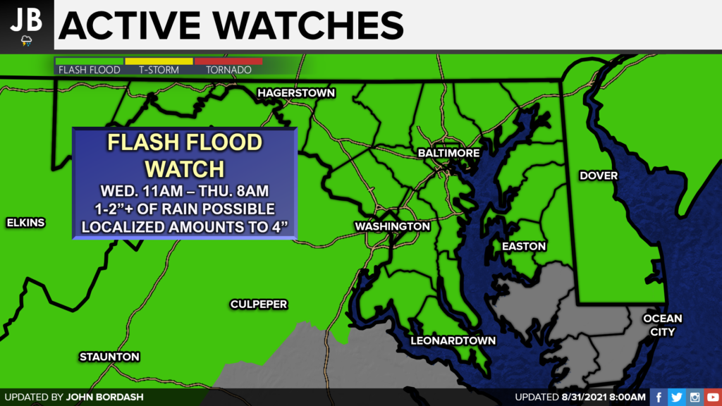
The National Weather Service has issued a Flash Flood Watch for our entire region for Wednesday, as we stand a good chance of seeing widespread flooding issues. While the heaviest rain may fall northwest of I-95, everyone has the risk of flooding, especially given the heavy rain we have seen over the last month.
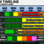
TIMING: We are likely to see rain break out across the region this evening. The rain has already begun falling in western areas this morning. We will see this rain gradually work its way eastward throughout the afternoon. By the afternoon rush, we may see some pockets of heavier rain. This will look to continue into the overnight hours. Areas south and east of I-95 are likely to see a break in the activity by Wednesday morning. Rain will continue falling northwest of I-95, but this should give our local communities a few hours to dry out. We then see an additional surge of moisture by the afternoon and evening hours. This will allow for additional, widespread areas of heavy rain to develop. Some spots may see as much as 1-2″+ an HOUR with some of these storms. We should begin to see the rain break up some overnight, with most of the showers getting out of here Thursday morning.
Shown below is our Chesapeake’s Bounty Futurecast model that really depicts all of this well.
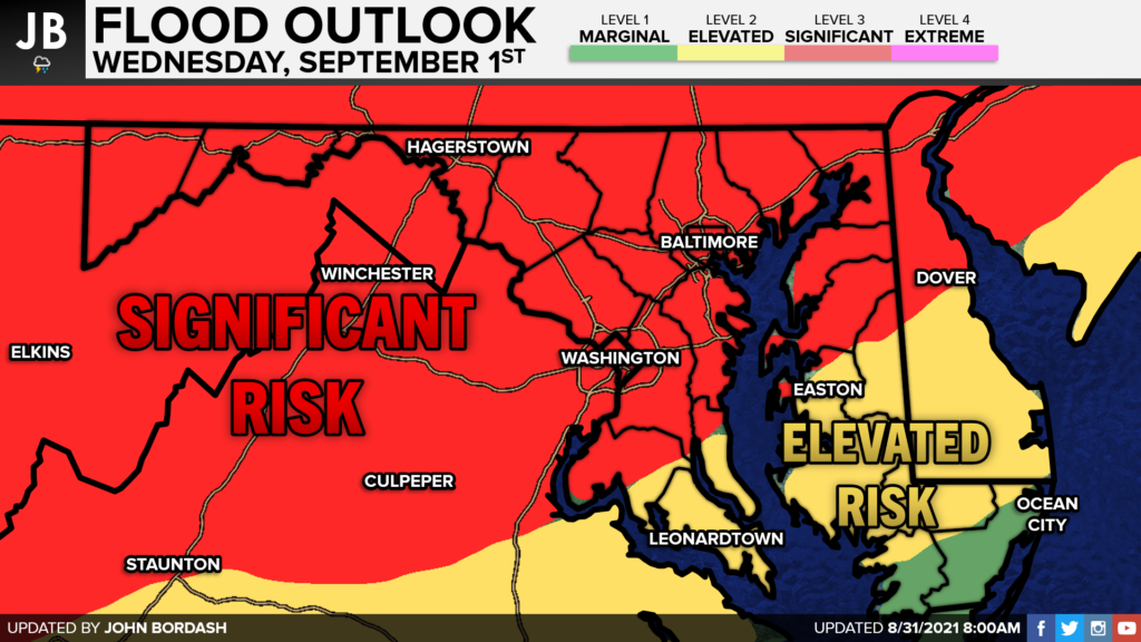
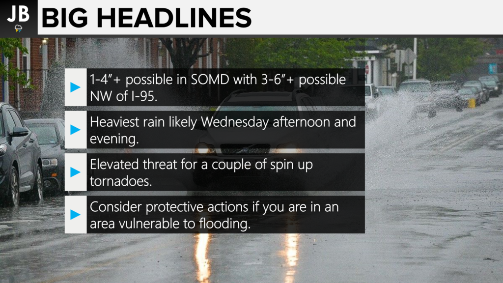
FLOODING: I think this goes without saying– we will see a lot of rain tomorrow. Our current guidance suggests that we may see 1-4″+ of rainfall across the area. All areas will have the potential to under-achieve or over-achieve these totals. The amount of rain you see will be highly dependent on localize, micro-climate factors that we just can’t forecast in advance. With this said– generally speaking, I think the highest totals will be across the northern/western parts of our region. Amounts closer to 1-2″ will likely fall through the southernmost parts of the area. This does NOT mean that southern areas will not see flooding issues. Much of this rain may only fall in a couple of hours, which would cause big problems. The highest totals of 5-10″+ look to fall NW of I-95. Heavy rain is more likely to fall throughout the day NW of I-95 hence the higher totals. Our totals are lower because we’re likely to only look at a few hours of heavy rain.
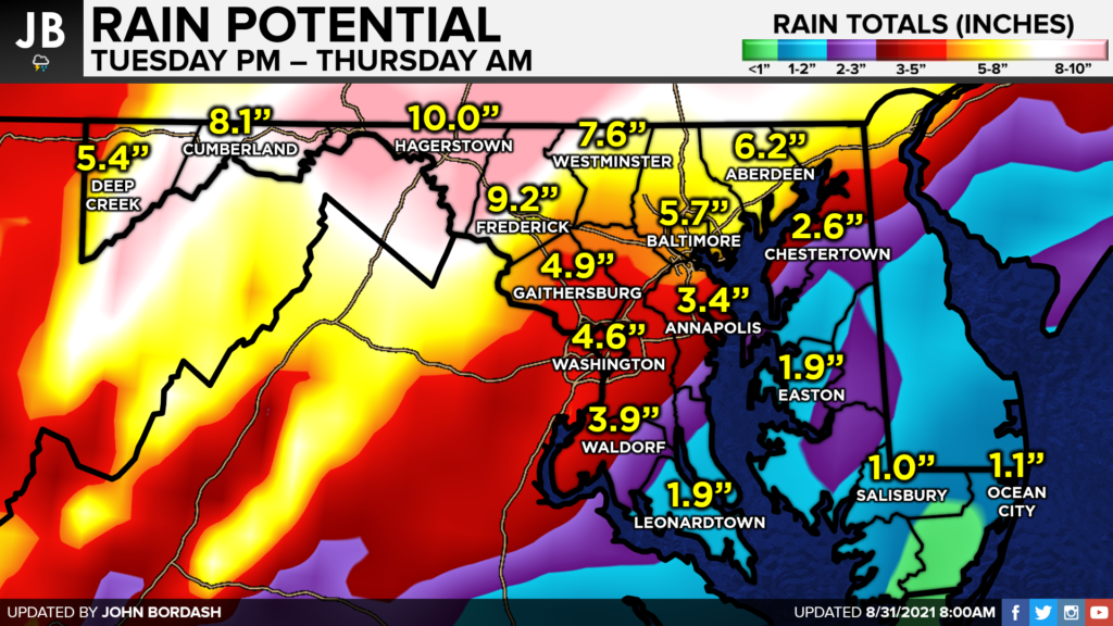
Given these numbers, it should come as no surprise to us that much of our region is under a Level 3 of 4 SIGNIFICANT RISK of flash flooding for Wednesday. This means that numerous flash floods are LIKELY. There could be significant, life-threatening flooding that occurs in several communities. Many streams may flood, potentially affecting our larger rivers. Southern areas are under a Level 2 of 4 ELEVATED RISK of flash flooding. This means that scattered flash flooding is possible, with a risk of a couple of communities seeing life-threatening flooding. The most susceptible and vulnerable areas are those that are somewhat more urbanized and areas that are close to streams and rivers.
It is important to note that EVERYONE has a heightened risk of flooding on Wednesday.
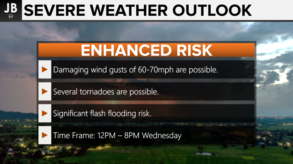
TORNADOES: A decaying tropical system brings with it additional turning and twisting of the winds throughout the different levels of the atmosphere. The different wind directions can help to give storms a little bit of a “boost” that forms on the system’s southern and eastern sides. Sure enough, much of our region will be south of the ultimate track of Ida’s remnants. Due to this, much of our region is under an additional Level 3 ENHANCED RISK of severe storms on Wednesday, which is largely tornado-driven. That is to say, our severe risk is this high mainly due to the heightened tornado threat. The other severe threats, such as thunderstorm-driven wind and hail, are low, but not zero.
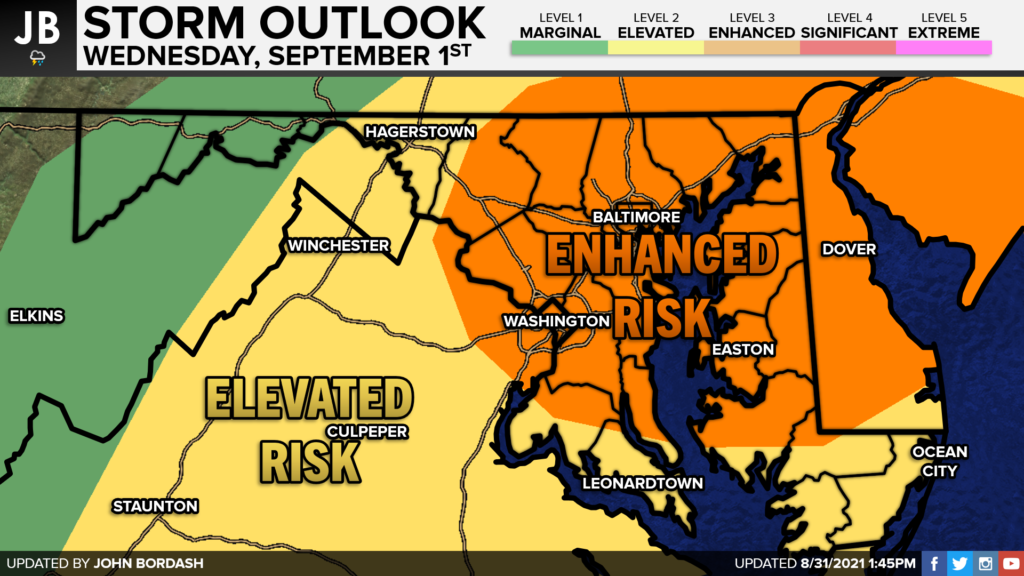
While a widespread tornado outbreak does NOT appear likely, a couple of rotating storms are possible tomorrow. While anytime between 6AM Wednesday and 12AM Thursday looks to be fair game for this risk, I would really hone in on the time between 12PM-9PM for our highest tornado threat. This is when we may see a line, or multiple lines, of storms form, and try to push the region. Typically when we see this occur, rotating storms are able to get embedded in those lines, and have the potential to produce weak tornadoes. Again, this risk is not the highest we have ever seen like it was with Isaias last year, but it is higher than normal. This will be something that I will be paying attention to especially closely.
SUMMARY: Wednesday looks to be an active weather day across much of the Mid-Atlantic. The remnants of Ida will likely bring heavy rain to many areas. Locally, we are likely to see 1-4″+ of rain that will look to be the heaviest Wednesday afternoon. 3-6″ of rain will likely fall NW of I-95, with zones in far Western MD and Central PA seeing as much as 6-10″+. Flooding will be likely for many spots. We also will have an elevated threat of seeing a couple of spin-up tornadoes, especially Wednesday afternoon. This is common with decaying tropical systems.
Be prepared for a high-impact weather day on Wednesday, and be ready to act if a Flash Flood Warning or a Tornado Warning gets issued tomorrow. As of right now, we do NOT have either of these alerts in effect. We just have a Flash Flood Watch up for our region. With that said, thunderstorms that have the potential to put down 1-2″ of rain an hour, and storms that may rotate, will be possible tomorrow and could impact the evening commute. Please, stay informed and stay weather aware tomorrow.
It will be important to stay with JB Weather for the latest information on Ida and her important impacts here in Southern Maryland. You can always access my forecasts and updates here on the website, on Facebook, on Twitter, and on YouTube. JB Weather is Southern Maryland’s Weather Leader, and I am working around the clock to keep you ahead of the storm!
-JB
Dr. Thomas Hao and Dr. Dylan Schneider offer comprehensive orthodontic services for all ages. Schedule your free consultation today. Visit www.SOMDBraces.com today for more information!
John Bordash
View More PostsJB Weather forecaster John Bordash is working around the clock to provide Southern Maryland, and neighboring communities, with accurate and reliable weather information.