The Storm Prediction Center has issued both Tornado Watches and Severe Thunderstorm Watches across the Mid-Atlantic as a volatile atmosphere continues to support severe thunderstorm development through this evening.
Thunderstorms are expected to continue developing east of the Blue Ridge before spreading toward the I-95 corridor and the Chesapeake Bay. While all areas under either watch face a threat for severe weather, there are some important differences between the two watch types.
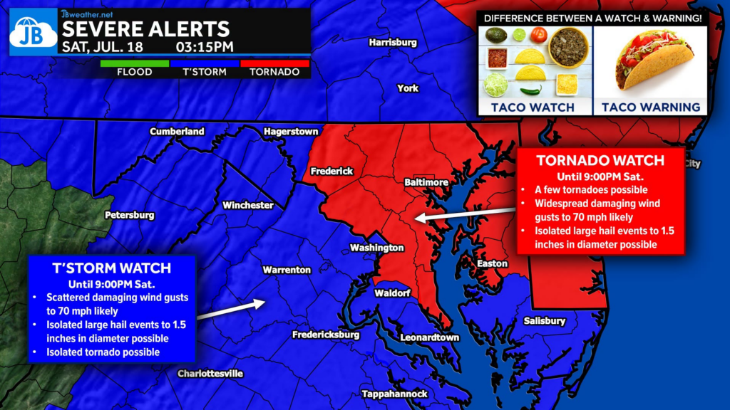
Tornado Watch (Until 9 PM)
Locally includes: Calvert, Anne Arundel, and Prince George’s Counties (along with the Upper Delmarva, northeastern Maryland, the Philadelphia metro, New Jersey, and Delaware).
This means the atmosphere is favorable for:
• 🌪️ A few tornadoes
• 💨 Damaging winds up to 70 mph
• 🧊 Isolated hail up to 1.5 inches
The Storm Prediction Center indicates the atmosphere within the watch area is favorable for supercell thunderstorms, which are capable of producing tornadoes in addition to damaging straight-line winds and large hail.
Severe Thunderstorm Watch (Until 9 PM)
Locally includes: St. Mary’s, Charles, King George, Westmoreland, and the Fredericksburg area (along with much of Maryland, Virginia, DC, and the eastern WV Panhandle).
This means conditions are favorable for:
• 💨 Damaging winds up to 70 mph
• 🧊 Isolated hail up to 1.5 inches
Storms within this watch are expected to organize and move eastward through the evening, with damaging winds serving as the primary hazard.
What’s the Difference?
A Severe Thunderstorm Watch means conditions are favorable for storms capable of producing damaging winds and/or large hail.
A Tornado Watch means those same severe thunderstorm hazards are expected, but the atmosphere is also favorable for tornado development. In other words, all of the threats found in a Severe Thunderstorm Watch remain, with the added concern for isolated tornadoes due to stronger wind shear and more favorable storm organization.
Bottom Line
Regardless of which watch you are under, everyone across the region faces a risk for severe thunderstorms through this evening. Damaging winds remain the primary concern, but those within the Tornado Watch should also be prepared for the possibility of isolated tornadoes.
Residents should monitor the latest forecasts, keep multiple ways to receive weather warnings, and be ready to move to shelter immediately if a Severe Thunderstorm Warning or Tornado Warning is issued for their location.

John Bordash
View More PostsJB Weather forecaster John Bordash is working around the clock to provide Southern Maryland, and neighboring communities, with accurate and reliable weather information.