Brought to you by Cedar Point Federal Credit Union
Winter has sprung to life this week as snow and cold have made a comeback across the region for the first time in nearly two years. Many spots picked up 2-4″ of light snow Monday Night and are waking up to temperatures in the teens this morning. And now as second system is likely to bring more snow and cold to close out the week.
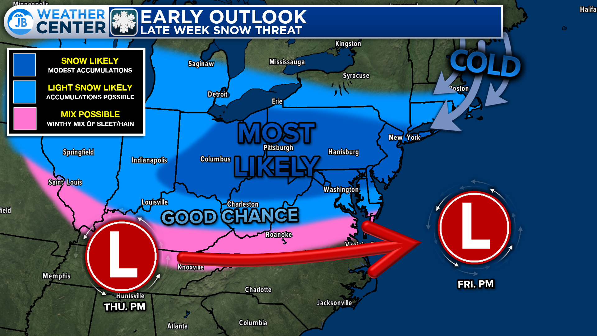
A developing system is likely to team up with a developing low pressure off the Carolina coast to spread a wide swath of precipitation Thursday night into Friday. We will see a fresh injection of cold air as these systems move through, which will help to ensure that most of this falls as snow. The biggest outstanding question is just how much moisture is around?
Our Cedar Point Federal Credit Union Futurecast shows precip moving over the Appalachian Mountains early Friday morning. This moisture spreads eastward into the freezing cold air. We are the most likely to see bands of more steady snow focus towards the north, just like we saw with this past system. Periods of snow linger throughout the day before ending Friday evening.
Our Cedar Point Federal Credit Union Futurecast shows precip moving over the Appalachian Mountains early Friday morning. This moisture spreads eastward into the freezing cold air. We are the most likely to see bands of more steady snow focus towards the north, just like we saw with this past system. Periods of snow linger throughout the day before ending Friday evening.
Storm FAQs
How confident are you in your forecast? I have moderate confidence with this forecast. The outstanding questions surround how much moisture exists with this system. A stronger system would lead to more moisture, and thus more snow.
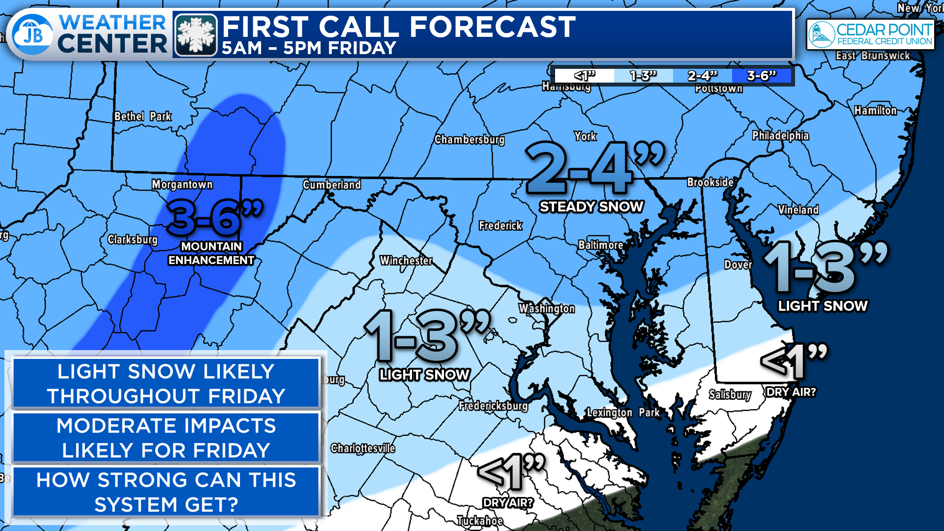
Where will the heaviest snow fall? The highest snow totals will be north of the DC metro area, where the precip will be the heaviest. However, even here, we are only talking a couple of inches.
When will the snow start? Current guidance shows that the snow is likely to begin during the Friday morning commute.
When will the heaviest snow fall? The midday hours on Friday are the most likely to offer widespread, steady snow.
When will the snow end? The snow should be winding down by sunset on Friday. Slicks spots will be left behind, though.
How much snow will I get at my house? Check out the accumulation map. Generally, I’m expecting a couple of inches for most spots with slightly higher totals north of DC.
Could more or less snow fall than currently forecast? Absolutely. For more snow to happen, we would need the system to starting trending stronger so that there could be more snow. More dry air, though, could lead to lower totals.
20% chance: Coating to an inch
60% chance: 1-3″
15% chance: 3-5″
5% chance: 5″+
Will the snow stick? The recent string of cold temperatures leading into the event means that whatever falls is likely to stick, even to roadways. Expect some slick spots.
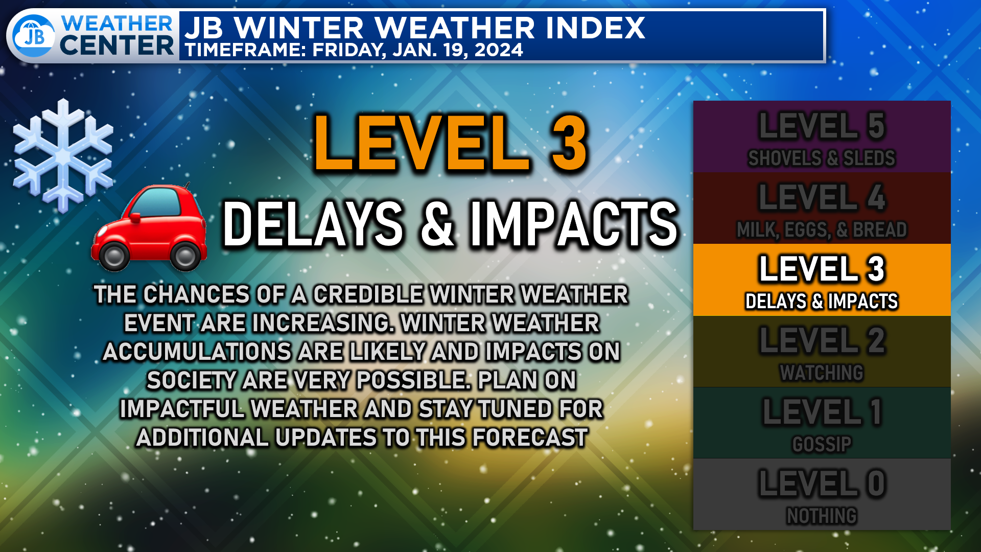
Like the last systsem, this is not expected to be a major snowstorm. However, widespread snow does look likely for the Mid-Atlantic. The timing of the event, with snow falling throughout the day, means that impacts are likely! I will have a more detailed impact forecast tomorrow as we learn more. This forecast is likely to evolve throughout the week as we learn more about the setup.
Stay with JB Weather for the latest information on impacts here in Southern Maryland. You can always access my forecasts and updates here on the website, on Facebook, on Twitter, and on YouTube. JB Weather is Southern Maryland’s Weather Leader, and I am working around the clock to keep you ahead of any storm!
-JB
Cedar Point has been providing trusted banking, lending and personal finance solutions to the Southern Maryland Community since 1945. Visit the credit union at any of its 6 locations in St. Mary’s, Charles and Calvert counties or online at www.cpfcu.com
John Bordash
View More PostsJB Weather forecaster John Bordash is working around the clock to provide Southern Maryland, and neighboring communities, with accurate and reliable weather information.