


Watching a Close Call: Snow Stays South… For Now
Another quick-moving system will slide off the coast Monday into Tuesday. Most snow stays south, but Southern Maryland is close enough to warrant watching.

Another quick-moving system will slide off the coast Monday into Tuesday. Most snow stays south, but Southern Maryland is close enough to warrant watching.
Dense freezing fog could make roads slick and drastically reduce visibility overnight.
From snowfall totals to school delays, here’s a full breakdown of how the storm performed.
A Winter Weather Advisory is in effect with a thin glaze of ice possible along and east of I-95.
Light, accumulating snow this morning will create travel issues across Southern Maryland.
Snow moves in after midnight and continues through midday Friday, with the heaviest totals south of D.C.
Since we already have school closures rolling in (King George and Westmoreland so far) I wanted to get this out! “Share” the word! I think […]
Winter alerts are now in effect for central Virginia as Friday’s storm could bring 1–2 inches of snow and some morning commute impacts.
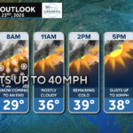
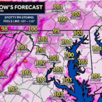
A cold start and a breezy afternoon will keep feels-like temps in the 30s all day.
Model disagreement continues, but the potential remains for light snow south of Route 50 for Friday.
John Bordash was born and raised in Southern MD. Living in the region for most of his life, he knows that the region receives very limited weather coverage, especially when dangerous weather moves in. John created JB Weather to keep Southern Maryland communities informed and prepared. From the southernmost tip of St. Mary’s to the 301-corridor, John Bordash is keeping you ahead of the storm.