


Light Rain on Tap for Tonight
A weak system brings periods of rain this afternoon and evening, with light but helpful totals.

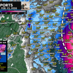
A weak system brings periods of rain this afternoon and evening, with light but helpful totals.
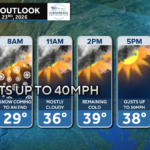
Northwesterly winds bring the coldest night of the season, prompting Freeze Warnings in Southern Maryland and Tidewater VA.
A strong cold front brings the coldest temperatures of the season.
Frost Advisories are in effect for Southern Maryland and the Eastern Shore as temperatures fall into the mid–30s overnight.
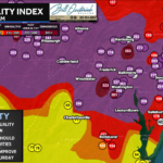
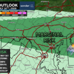
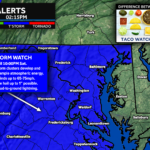
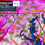
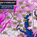
A few embedded storms may develop today with a low tornado and flooding threat, though widespread severe weather is not expected.
A developing storm may bring 1–3 inches of rain, rumbles of thunder, and coastal flooding from strong onshore flow.
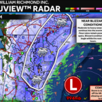
Hurricane Melissa has intensified into a Category 5 storm and is expected to make catastrophic landfall in Jamaica tonight.
Melissa could become a major hurricane by Monday, with Jamaica and Cuba facing potential impacts next week.
Storms after 8 PM may bring thunder, gusts, and a brief spin-up east of the Bay before cooler air settles in.
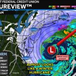
Our first true Nor’easter arrives this weekend with soaking rain east of I-95 and breezy, unsettled conditions region-wide.
John Bordash was born and raised in Southern MD. Living in the region for most of his life, he knows that the region receives very limited weather coverage, especially when dangerous weather moves in. John created JB Weather to keep Southern Maryland communities informed and prepared. From the southernmost tip of St. Mary’s to the 301-corridor, John Bordash is keeping you ahead of the storm.