


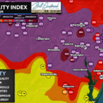

Update: Elevated Severe Risk Remains For Thursday Evening
The severe weather threat across our region remains conditional and a bit uncertain. Areas south of DC across Southern Maryland, the Northern Neck, and portions […]

The severe weather threat across our region remains conditional and a bit uncertain. Areas south of DC across Southern Maryland, the Northern Neck, and portions […]
After a few much-needed showers this morning, especially across northern and western portions of the region, we’ll see conditions improve through midday with increasing sunshine […]
And there we have it, our first named storm of the 2026 Hurricane Season has formed! Tropical Storm #Arthur has formed off the Texas coastline. Arthur will […]
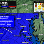
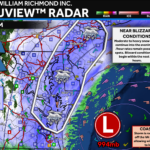
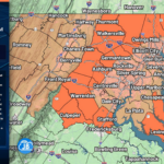
The Storm Prediction Center has issued a Severe Thunderstorm Watch for Washington D.C., much of Maryland west of the Bay, central and northern Virginia, the […]
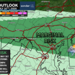
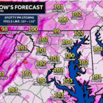
After a quiet and comfortable Saturday, the atmosphere is rapidly becoming more favorable for severe thunderstorms across the Mid-Atlantic today as heat, humidity, and an […]
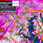
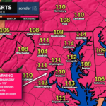
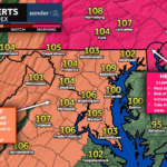
The heat and humidity are back on for today as temps race into the mid-90s with feels-like temps around 100° this afternoon. We will see […]
After a quiet and comfortable Saturday, the atmosphere will quickly become more favorable for severe thunderstorms on Sunday. A cold front approaching from the west […]
The Storm Prediction Center has issued a Severe Thunderstorm Watch for much of Maryland, Virginia, Washington D.C., eastern West Virginia, and adjacent coastal waters through […]